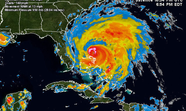
Boats evacuated from coast as Category 3 storm barrels toward North Carolina coast.
Concern among Carolina’s coastal residents heightened today (Aug. 25) when the NOAA National Hurricane Center shifted the forecast track of Hurricane Irene to the west during its 11 a.m. update, intensifying the need to be ready for the oversized storm barreling toward the eastern seaboard.
At Southport, on the far southern end of the North Carolina coast, Capt. Butch Foster, said he and many of his fellow charter fishermen were intently watching the updates and expecting the center of the storm to pass 50 miles of so offshore in the ocean.
“We know we are going to get some tropical-storm-force winds and rain, but expect to be the least affected of anywhere along the coast,” Foster said. “Fishermen with smaller boats and access to trailers have been pulling them inland or putting them in storage facilities in the area.”
“We don’t have the option of that, so I’m going to double all the dock lines, triple check them and leave it in the hands of the good Lord. Unless it shifts farther to the west, we should be all right.
Roughly 100 miles farther up the coast at Atlantic Beach, the mood was much more somber. Fishermen and other boaters are expecting a rough go of it, and are making preparations to weather it since the shift of the forecasted track has the eye passing between Atlantic Beach and Cape Lookout.
“The Atlantic Beach Causeway in front of my store looks like a boat parade,” Capt. Matt Lamb of Chasin’ Tails Outdoors said. “They are hauling (boats) inland as fast as they can. The folks with smaller boats that are on lifts (with) no way to move them are tying the boats to the lifts and raising the lifts as far as they will go.”
Those boats that could be removed from the danger zone already are gone, Lamb said.
“Most of the big boats that dock along the causeway are already gone,” he said. “Many have been taken to area boat yards, and have been pulled and blocked on land. Others have been run up or down the coast and are berthed or anchored in places the owners think will be safe.
“By this time tomorrow, most of this will be done and we’ll be looking like a ghost town. Many businesses are boarding up, and we will, too.”
After crossing into Pamlico Sound, the current forecast calls for the center of Hurricane Irene to move inshore of Hatteras and Ocracoke. This creates special issues, as it places those areas in the northeast quadrant of the storm, which is historically the strongest.
Flooding problems are anticipated.
Calls to Ocracoke and Hatteras were not answered and haven’t been returned yet.
Bruce Armstrong Jr. said he talked to his dad, Capt. Bruce Armstrong Sr., who had taken his boat, Sea Angel II, to Coinjock and was berthed in a narrow and protected section of the Intracoastal Waterway through Currituck Sound.
Armstrong Jr. said his dad was at first planning to ride the storm out at his home in Hatteras, but changed his mind this afternoon and was heading inland to Tarboro to stay with family.
Be sure and post any information you might receive on coastal preparation in the reports forum. If you aren’t already a registered NorthCarolinaSportsman.com user, it only takes a few minutes to get started!


Be the first to comment