A late-summer trip to the South Fork of this ancient river offers scenery and bronzeback action.
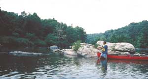
The riffle flowed into the pool at its left side and, as the canoe made its approach, Kevin Hining recognized the inherent potential. At its right side, the hole featured numerous basket-size boulders, several eddies, a shaded shoreline and well-aerated water.
As Hining, who hails from Moravian Falls, guided the canoe through the riffle, I dug the paddle into the swift water so the boat would slow its pace then loop into some adjacent slack water. Our goal was to be free from the riffle’s influence but not so far into the pool that we alarmed any lurking smallmouths.
A cast of a soft-plastic jerkbait into the pool immediately resulted in a resounding thump but no hookup. After the next cast, a quick strike ensued and this time a little quicker hookset resulted in a 15-inch bronze bass, the day’s first keeper but not the last.
Hining, a District 7 fisheries biologist for the North Carolina Wildlife Resources Commission, was visiting the South Fork of the New River, specifically that section from the U.S. 221 Bridge to Kings Creek Road.
Last year’s late-summer smallmouth success occurred during the first of a two-day float at this northwestern N.C. highland jewel.
“On the South Fork, it looks like the last couple years we may have had poor (smallmouth) spawns,” he said. “But previous years don’t appear to have been that bad.
“For instance, the 1999 and 2000 spawns appear to have been good ones for the South Fork. So it looks like spawning success at the South Fork has been a little better during the last few years than Virginia has seen at the Main Stem of the New.
“It also looks like we have about the same number of fish in the South Fork we did during 1997 and 1999 surveys. But our number of larger fish appears to be lower than before. So our data suggests we now have fewer large fish than in previous years.”
Hining shared some of the other survey data, including an interesting tidbit that at the South Fork of the New River, a 10-inch smallmouth is likely 3- to 4-years old, and smallies longer than 12 inches are probably older than 5 years.
That information indicates bronzebacks grow slowly in the South Fork. Growth rates of smallmouth bass and other gamefish in the New River system probably increase the farther an angler floats downstream, probably because the river has an increased level of nutrients, the biologist said.
For a regular New River angler, that means the slow growth rates emphasize the need for to release smallmouths longer than 12 inches, especially bass 15 or more inches in length. A fish in the 15-inch range could well be more than 7 years old and beginning to reach a size where it adds substantial girth. Anglers should catch, photograph and release brown bass of this size and larger.
U.S. 221 Bridge Float
Jed Farrington, who operates Zaloo’s Canoes at Jefferson, said the section of the South Fork that falls within the 26.5-mile portion of the National Scenic River offers the best smallmouth action of the entire South Fork.
Of that stretch, 22 miles is the South Fork and the last 4 miles follow the confluence of the South Fork and North Fork, south of the Virginia-N.C. border.
Hining said the U.S. 221 Bridge excursion is good for smallmouth bass action, especially during late summer when the upper stretches of the South Fork may have lower water levels.
Most of the first mile of this junket offers limited fishing for smallies. Shallow bedrock characterizes much of this mile, which features few riffles and dropoffs. The river’s left bank is void of cover, so quickly paddling through this section is recommended.
Toward the end of that mile, anglers encounter a left bend that features a heavily-wooded bank, riffles and a boulder-laced pool. It’s a quality place to wet a line, as are the riffles that lead out from the bend.
Numerous underwater boulders and ledges dot this section. Next comes a river right bend, and a wooded shoreline characterizes this curve that offers good fishing opportunities.
Although the put-in for the U.S. 221 Bridge to Kings Creek Road (7.5 miles) float is listed in the “New River State Park” brochure that contains canoe access points, float fishermen must note the U.S. 221 access is at private land owned by New River Outfitters at Jefferson.
The livery is located at the historic New River General Store, a few yards from the bridge. For more information, contact the livery at (800) 982-9190 or (336) 982-9192, www.canoethenew.com. The put-in is on river left just downstream from the 221 bridge. Anglers/canoeists will have to haul their crafts down a grassy bank.
The South Fork then straightens once more and the banks feature assorted hardwoods, sycamores, silver maples and river birches. Yet another curve then appears, this one a left-outside bend. Any wooded outside bend at the South Fork is worth fishing extensively.
Later the stream straightens as homes and fields dot the river’s left bank. Toward the end of this straight stretch lies a deep pool known locally as the “Blue Hole.” Hining said this hole has a reputation for harboring giant muskies. A few casts with oversize minnow plugs might be in order.
The South Fork then makes a right bend and presents a series of boulders, riffles, an easy Class I rapid. Not far below this swift water looms an interesting rapid and a superlative place to fish. This locale features a Class I rapid to the left of an islet, and a Class II to the right. The latter also contains some boulders, so it’s recommended to run the Class I rapid on the left side. It has a dogleg-type pathway.
Paddlers should drift through and carefully probe a series of riffles and rocky pools. The left bank especially is wooded and offers more casting opportunities. Rhododendron also cover the bank in places.
Soon the river’s course passes a red barn on the left, a structure that serves roughly to mark the halfway point of the float. No more major bends exist on the getaway, and there aren’t as many good places to fish.
Anglers should paddle quickly through a flat, wide, shallow stretch until they come to an island with riffles at both sides. Many good spots exist downstream from the island.
Next comes the Topia community on river’s right shoreline; however, it’s not visible from the South Fork. Scattered homes line the river’s left bank, while the right shoreline is mostly wooded. A small stream also enters from the right.
Another stream will enter on the same side less than a mile downstream. A number of boulders line the stream bottom, and fishing possibilities are more numerous.
During the last mile of this excursion, more homes will appear, but anglers also will drift through some 3-feet-deep rocky flats that harbor bass. Look for the dropoffs and occasional riffles and concentrate fishing efforts at those places.
Next comes an easily passable Class I rapid, which sometimes drops to riffle level, depending upon the water level.
Downstream lies the Kings Creek Road access point at the river bank. It’s an excellent access point, as a gravel ramp and wood steps lead away from the river. Numerous parking spaces exist at a gravel lot. The low-water N.C. 1560 Bridge also crosses the South Fork here. All low-water bridges on the river require portages.
Kings Creek Road Float
Jed Farrington said the Kings Creek Road (SR 1308) float is yet another with a reputation for producing quality smallmouth action.
At the put-in, two outfitters, RiverCamp USA and Riverside Canoe & Tube Rentals, are at the right and left banks, respectively. The the river serves as the boundary for Ashe and Alleghany counties.
The Kings Creek Road float (Kings Creek enters the river at the beginning of this trip) is one of the best on the entire South Fork.
Although this junket is short, just 2 ½ miles, it contains a great deal of quality brown bass habitat. At the start of the float, Garvey Bridge Road (S.R. 1549) is visible at the left shoreline, but the bank is rather barren and the water shallow, so smallmouth numbers are low.
The further downstream from the access point one travels, the better the habitat. Soon the shorelines become mostly wooded as anglers leave behind scattered fields and homes, and the pace of the South Fork increases. About ¾ mile into the trek, a series of ledges and riffles, which may in high water reach Class I size, appear. These riffles offer fishing opportunities.
At about the 1 ½-mile point, the South Fork forms a lazy left bend, and a riffle lies near the end of this curve.
Two major features mark the next section, the first being Twin Rivers Campground at the left bank. Unfortunately, this business has removed a great deal of shoreline cover that once provided good habitat for smallies and other gamefish. In its place are closely-mowed grass and an eroding shoreline.
The second feature is one of the major rapids of the South Fork, a Class II that lies at the former site of the New River Forge. According to The New River Atlas (a valuable source of information for the South Fork and Main Stem), an 1878 flood washed away the forge and dam. However, debris from this disaster created excellent smallmouth habitat, and numerous large rocks dot this area along with log jams.
Anglers should be aware this rapid can be dangerous during high water periods or even at moderate flows. Portaging is a sensible solution.
The New River Forge rapid lies at the beginning of a sharp right-outside bend. The river’s right shoreline is heavily wooded, and rock and wood cover are common.
Anglers should linger in this area and work it thoroughly.
More superb cover lies downstream where the South Fork’s course straightens. Riffles and current breaks are common, and trees cover the right bank, much of which the New River State Park owns. Only one-half mile of paddling is needed to reach the confluence of the South and North Forks.
It’s not a bad idea to paddle up the North Fork and make a few casts for smallmouths. Anglers usually will be rewarded for their efforts.
After reach the confluence, anglers should paddle across the New River to the left bank. An informal access point lies off East Weaver’s Ford Road. Anglers will have to haul canoes up a narrow, dirt path that leads down from the road. Parking consists of roadside pulloffs.
The South Fork of the New features a number of other fetching floats.
A major smallmouth trip is 5 1/2-miles long, from the N.C. 163 Bridge to Elk Shoals Methodist Campground. But during early fall, this trip can have low water levels. However, if floating isn’t possible anglers can wade and cast at this stretch and catch smallmouths and rock bass.
Also noteworthy is a float from the S.R. 1159 Bridge to the N.C. 88 Bridge (6.0 miles), which is where Zaloo’s is located. Downstream from the livery exists another superb summer getaway — the 5-mile-long N.C. 88 Bridge to Wagoner Road access float.
Just as good is the 5 1/2-mile-long Wagoner Road Access to S.R. 1595 Gentry Road Bridge trip.
Another getaway worth exploring is Gentry Road Bridge to U.S. 221 Bridge, a 7 1/2-mile-long float.
If the 2 1/2-mile-long Kings Creek Road Bridge to the North and South Fork joining float isn’t of sufficient duration or if anglers would like a longer trip, consider continuing on the Main Stem down to the Mouth of Wilson takeout next to the Route 93 Bridge in Virginia.
That trip adds 5 miles to the Kings Creek Road junket, but it’s highly recommended; the smallmouth habitat along this stretch is marvelous.
Even better, Virginia and North Carolina have a reciprocal-license agreement, so Tar Heel anglers don’t have to purchase an Old Dominion fishing license.


Be the first to comment