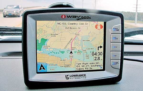
I always thought that as boaters, we were generally a little more savvy about GPS navigational units, but the recent onslaught of optional equipment and standalone automotive GPS units has the general public using them for many trips longer than to the neighborhood grocery store.
The primary difference in automotive and marine GPS units is how they navigate. Automotive units are map-based and give turn-by-turn directions, while marine units offer straight-line directions to the chosen location. Unfortunately, the straight-line navigation doesn’t warn about shoals, jetties, points or other obstructions that could be along the path.
Unlike a driver, the marine navigator must know his area and set up a route to navigate along channels and around obstacles. With the technology in place to give turn-by-turn driving directions, one has to wonder when this will become a feature of marine navigation? I believe I like the idea of keeping the helmsman involved and responsible, but heck, I still often disagree with the turn-by-turn directions in my vehicle.
Automotive units also have voice prompts for upcoming turns and many have the option of selecting shortest route, quickest route, omitting toll roads, plus other personal preferences. The ability to tune my road preferences is nice, but sometimes, that dang voice prompt just tends to annoy me. The nice thing about this feature is that unlike an argument at work, nagging at home or other exasperating vocal encounter, you can win this one by default by simply turning off the volume.
For the first few years, I wasn’t a big fan of automotive GPS units. Having driven across most of North Carolina, plus several other southeastern states, I have a working knowledge of backroads, shortcuts, traffic-dodger routes and other potential aids, so I didn’t feel the need for assistance. However, once I used automotive GPS to find several downtown locations in busy cities with way too many one-way streets, I began to see their value.
Once I got over my mental opposition to getting driving directions from a box on the dash, I began looking for the right automotive GPS for me. Looking back, it is now a little curious, in a humorous way, that I trusted several versions (Loran A, Loran C and now GPS) of dash boxes with my navigation at sea, but was skeptical on land?
Now that I’ve used them a while, I believe automotive GPS units have some personality, which can be enhanced or reduced by choices of the voices, languages and accents used for the voice prompts and the tuning of routing preferences. With this in mind, I feel it is important to find the right one. One company has started offering an auto GPS for NASCAR fans that uses Dale Earnhardt Jr.’s voice. How’s that for personality?
In working to my personal preferences, I found I liked two units made by Lowrance: the iWay 600 and the XOG. Not only do these units have significant physical differences, they are hundreds of dollars apart on the cost scale. There’s no accounting for taste and these are the units I like regardless, both large or small and inexpensive or not. The feature that initially intrigued me is their ability to function in both automotive (turn-by-turn) and marine (straight line) navigational modes. I still find this very interesting even though I have only used them on a boat a very little, mainly for testing purposes.
What’s that? Yep, you heard me right. While automotive navigation as the default, with a fairly simple series of commands, they can be switched to marine navigation.
I don’t know about everyone else, but when I found an automotive GPS that could double as a backup on my boat, I had to check it out. Thanks to the generous folks at Navico, I was able to “sea trial” both for several months and check them out. At the end of the sea trial I purchased one, but I won’t reveal which until near the end of this.
The Lowrance iWay 600 and XOG GPS units are fine units and both would serve my purpose well. The obvious difference is size. The iWay 600 is much larger — larger screen, larger buttons, larger on-screen prompts and easier to see. It comes with a larger processor, complete with stored Navteq U.S. road maps, MapCreate North American topographical maps (also includes underwater features in thousands of lakes), NauticPath U.S.A. marine coastal charts, much more memory and can also serve as a MP3 player.
Apparently, the mapping operations of the iWay 600 are interlinked. Whenever I crossed a bridge over navigable water, it would display the roads, the water and any navigational markers within the scale it was using at the time. This happened numerous times crossing the Intracoastal Waterway and was quite entertaining parked on the Southport waterfront, or headed to the Outer Banks and similar locations surrounded by a lot of water.
If there is a negative with the iWay 600, it is the weight. The suction-cup mount is not strong enough to support it on a windshield and is not recommended even for stability on a boat; specialty mounts are available. Having a processor with this capability requires a large heat synch, which keeps the unit running fine even when sitting in a hot summer windshield, but adds weight.
While Lowrance may not think of it exactly so, I see the XOG as a little brother to the iWay 600. The overall size, screen and processor are smaller and it is significantly lighter, but it will do most of the same things. The iWay 600 is water resistant, and the XOG is not, but with protective placement or a waterproof cover, the XOG will serve as a backup marine GPS. The XOG also has an internal battery that stores enough power to run about 2½ hours. Steve Hamber, Navico’s regional sales manager, said this is enough time to get in a good mountain bike ride with it on an accessory handlebar mount to provide the route.
With its smaller processor, the XOG does not arrive with all the mapping data pre-loaded. It comes with the Navteq road-map information loaded, but it requires a free download of MapCreate topographical mapping software or Lowrance Enhanced Lake Maps from the Lowrance website (www.lowrance.com) or optional NauticPath USA marine charts, Fishing Hot Spots Elite lake maps, Navionics marine charts, Freedom Maps for North America and Europe or LakeMaster ProMaps to operate in point-to-point navigation mode. Accessory maps, like the Navionics Marine Charts, can be purchased on a SD format memory card, which is inserted into a slot on the left side of the unit.
Once the appropriate accessory map is downloaded or inserted into the SD-card slot, the XOG uses the same command sequence as the iWay 600 to switch to marine (point-to-point) navigation. I happen to prefer the Navionics cartography (the XOG uses Navionics gold series) to the NauticPath USA marine coastal charts, but that is a personal preference. Both provide excellent navigation cartography, plus tide and marina information for numerous points shown on the chart. Both units will also allow using pre-set routes for cross-country or marine navigation.
Much like the iWay 600, the XOG will also function as a MP3 player. However, because of the smaller memory, the music must be downloaded to a SD card and played from there. The XOG can also function as a picture viewer. It will view .jpg or .gif image files from a SD card inserted in the card slot on the left side. It also allows viewing the images directly from the SD card in my digital camera. I can only assume it will also view the pictures from other cameras that use SD cards. This doesn’t sound like such a big deal and wasn’t something that initially appeared to be something I would use, but I have found it allows me to quickly view images in a larger format than a camera’s viewfinder, without having to boot up a laptop.
Both units have the ability to find restaurants, gas stations, motels, airports and other points of interest. This can be nice when you are out of town and need some help. While pulling over to operate the device is a wise safety move, you don’t have to get out and go into a service station or convenience store to get directions you can’t (or won’t) follow.
After using both GPS units for several months, I decided to purchase the XOG. They are both excellent units, and it was a difficult decision, with ether option having benefits. Sure, my tired old eyes appreciated the larger screen of the iWay, plus having a waterproof case with everything self-contained was nice, but I found I preferred the versatility, compact size and lighter weight of the XOG. I thought I would never use the internal-battery function, but I already have, several times. I thought the same of the picture viewer, but I often use it to review pictures I have taken earlier in a day.
I guess I should also make you aware there is also a significant price difference between the two units. I’m frugal — my wife says often to a fault — but I didn’t select the XOG simply because it is hundreds of dollars less expensive. I selected it because it proved to be the best option for me. Sure, the price was a bonus — and it is occasionally run on sale — but where else can you get an automotive, marine and cross-country GPS that can be self contained, cordless and allows checking the .jpg images I took in time to take more if needed?
This unit keeps me on track and gets me where I tell it I want to go. I don’t get lost any more, but on those occasional times when I enter an incorrect destination, I can listen to music while correcting my error or check out my latest pictures while waiting for AAA to bring me some gas.
NOTE: The iWay 600 typically sells for $599 to $749, while the XOG is usually $229 to $259. Several high-volume electronics outlets have run it on sale for $159 numerous times already this year.


Be the first to comment