Ever had one of those days when you couldn’t locate fish, looked to the sky as a sort of final distraught gesture, spread your arms and said, “Where are the fish?” Oddly enough, you might not have been too far off in turning to the heavens for relief. How about if you could have asked that question before your trip and resolved fish-location questions before a fishless day and frustration overwhelmed you?
I’m not talking about actually turning to the Almighty with something as trivial as fishing information, although a good relationship with Him probably wouldn’t hurt. He obviously smiles on fishermen; note how many anglers Jesus chose for disciples.
What I’m speaking of is the latest in seawater-imaging information used for locating preferred concentrations of water.
One of the primary keys to finding “fishy” waters is temperature. Other factors include salinity, water color and current flow history. With the exception of times of heavy cloud cover, many weather satellites can track and grid all kinds of information from water and land across the world.
This new device contains “real-time” imaging. Numerous satellites with the capability to monitor physical conditions orbit the earth and relay facts to computers that plot images.
Depending on exactly how you receive the information, it could be a few minutes old to a maximum of several hours. Either way it’s more current than the “this-is-where-I-caught-them-yesterday” information obtained from friends and fishing buddies — even though word-of-mouth reports can be important.
The value of this information varies with the type of fishing one prefers, but it can help with almost any kind of angling. It’s most commonly used to locate the Gulf Stream and its surrounding eddies and fingers, which may hold fish.
The initial technology has been around for a while, and many savvy fishermen — particularly charter captains — have been taking advantage of it for more than 20 years.
Even better, the technology keeps improving, as does most computer software. Satellite fishing information today is better, with many more options, than it was just a few years (or even weeks) ago.
The scope of information runs from free postings at internet sites to lightly-analyzed facts via subscription services to subscription internet sites with much information where the angler must do his own analysis to subscription services with highly-analyzed data that can be e-mailed or faxed to a home, office or directly to a boat with appropriate cellular or satellite phone/internet capabilities.
Is there a need for high-tech delivery systems of fishing information? You bet.
Any information a fisherman can find that helps him locate or catch fish is a plus. Why do you think so many fishermen belong to clubs where they can exchange information, go to boat and fishing shows? Some businesses — such as North Carolina and South Carolina Sportsman Magazines — offer a series of day-long fishing schools. Plus, many anglers read numerous fishing publications to search out information.
Fishermen are information hounds; most are willing to run to great lengths and crawl through the thickest briars to know all they can. Even better, when they can apply knowledge to fishing and improve their catch, they know it’s working.
This instinct to gather and hoard information is even more important to tournament fishermen. Many tournament fishermen spare no expense in getting the best boat, with the highest horsepower motors and equipped with the latest marine electronics. But modern marine electronics systems go well beyond GPS, sounders, radio and radar to include satellite phones, weatherfax systems and more.
Many larger boats — with a computer linked through the satellite phone or directly to a satellite internet service — today are considered standard.
With these advances, modern captains now can download the latest internet postings or analyzed satellite images. Even better, this information comes in “real-time” form, in many instances only a few minutes old. In some situations, the latest download is more current information than the last fish you caught.
OK, so now you can find just about everything but a fish’s preferred lure color and bait and have the information delivered either prior to casting off or by satellite to your boat. That is great for the tournament fishermen, but how does it affect average fishermen?
It’s human nature to want to excel. The question of “what did you catch?” is a great way to begin a conversation without immediately bragging about one’s own catch. Most fishermen ask their buddies such questions at the end of the day and hope to be able to spin a slightly better yarn. To do this they’ll spend considerable time, effort and money.
Gathering the “where and when” information before leaving the dock is always a smart move. Free information is better than none, but the subscription services usually go it one better. Sure, there’s a charge for this information, but in these times of marine fuel approaching $3 per gallon, expenses can be overcome perhaps with a more direct route to a better bite.
I’m not promoting any particular brand of these services, but promoting their availability as another tool for helping anglers locate fish — which is part of my job. Options other than the examples I cite are available, but I have to cite information known to me.
Two of the free sites are the Rutgers University Marine Science site at http://marine.rutgers.edu/mrs and the Hotspot Charts, LLC site at http://www.sstcharts.com. At the Rutgers site, the Cape Hatteras chart covers North Carolina. In fact, it actually covers water from Virginia Beach, Va. to Cape Romain, S.C.. The Hotspot Charts site for the NC Coast chart covers from roughly the N.C.-Va. state lines down to the Wrightsville Beach side of Cape Fear. The N.C.-S.C. Border Chart covers from roughly Cape Lookout to Cape Romain.
At these sites other tools are available in addition to seawater thermal charts, but anglers must do all their own analyses. Other info includes archives to look at the recent past to aid with observations. If one feels personally comfortable analyzing such information, it’s available at no cost on-line. Undoubtedly, this type information is far superior to no information at all.
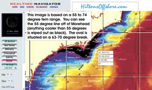
The Hilton’s Realtime Navigator site (http://www.realtime-navigator.com) is a subscription site with on-line tutoring where anglers do their own analyzing. Hilton’s N.C. information area covers roughly Virginia Beach, Va., to Myrtle Beach, S.C.
For anglers who like to obtain information and analyze it, Hilton’s may be the ideal site. It’s fully automated and offers regular updates. Hilton’s also offers retrievable data.
Altimetry is the study of elevated or lower ocean levels, which basically means “upwellings” that are generally considered positive areas for fishing or “downwellings,” generally considered not-so-good places.
Sea-temperature imagery is what it says; it allows anglers to locate areas of preferred temperatures for targeted species.
Chlorophyll readings at the Hilton’s site measures chlorophyll levels and roughly translates to water color.
Also at the Hilton’s chart is information about water salinity, bottom charts, waypoints for known structure and a weather radar scan from the time of the satellite pass.
Many knowledgeable fishermen regularly use the information available at the Hilton’s site as major factors in planning fishing trips.
The oldest of the businesses offering satellite imagery for anglers is ROFFS (Roffers Ocean Fishing Forecasting Service). Located at the internet at http://www.roffs.com, or by phone at 305-262-8336 or 800-677-7633, ROFFS is a subscription service that analyzes all data for anglers.
Dr. Mitchell Roffer was the first to offer these services and began his service during the late 1970s. Roffer’s information has such an excellent reputation that oil companies and other businesses also use the service.
A ROFFS analysis includes a labeled chart (black-and-white by FAX or color by e-mail) and a separate page with detailed analyses and suggested hotspots for chosen targets. A ROFFS analysis takes into consideration water temperature, how long that water has been at that temperature and in that area, water color, presence of bait, catches from the area during the past few days and other information.
These services have proponents and detractors.
My suggestion would be to visit the web sites, then call and speak to their experts. Some info exchanges are free and some have subscription fees, but each service will help anglers head to an area that should hold fish.
Once upon a time, the ancients looked to the stars to provide information about the future. But that practice fell into disrepute because it had more to do with reading animal entrails and casting bones than science.
But today with satellites whirling above us, the time to cast an eye to the heavens for fishing help appears to have returned. Anglers now can look skyward and offer thanks, rather than wondering what happened to the fish.


Be the first to comment