


Hunting is a part of human civilization dating back to the beginning of time when humans first walked the planet. In the beginning, hunters were outnumbered by their prey. So managing the resource was far from their minds.
But as civilization developed and more consumers entered into the population, the thought of an endless pool of game was realized to be a false premise. Consumers needed to manage their resources for sustainability.
Today, hunters and land managers on a government and personal level work together to effectively maintain rich habitats and plenty of game to go around.
The modern-day human lives and breathes with technological advances in just about everything we do. And hunting and land management activities aren’t immune. But the advances in technology have improved the ability for people to connect better with nature. And to reach their natural resource goals.
Surely some aspects of technology have taken people away from nature. But many 21st century tools have shortened the gap between our goals and aspirations to improve and better understand hunting properties.
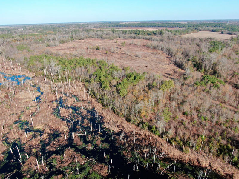
Hunters and land managers have used aerial photographs for decades to better understand their properties. But with the advent of consumer drone technology, the common hunter can afford a high-tech drone package to examine their properties from practically any altitude and in real time.
Real-time vision
Recreational drones are used by a wide range of folks from just a weekend hobbyist to professional videographers. The entry range price for drones starts at just a few hundred dollars. And it goes up to several thousands for a feasible unit that can be beneficial for hunters. For the price of ammo, corn, gasoline, and other consumer products used for hunting on the rise, a drone package for $350 seems like an inexpensive investment that is well worth the cost.
What can a drone really do for a hunter that an aerial photo from Google Earth can’t provide? Well, aerial photos and a snapshot of various historical aerial photos from Google Earth are excellent resources for land managers. And they are also free. So, the ability to use online aerial images is excellent for hunters and landowners. But they still lack some of the unique features that a drone can offer.
First of all, the available aerial photos are typically 2 to 3 years old, if not older. The aerial snapshots are taken at fixed periods. And the time of year these photos were taken can determine how usable the images are. Most of the time, the available images are dated and will not have the most current conditions of the property. Drone photography can provide real-time looks of the land.
Great for scouting
Drones can take photos at any elevation as long as they are under 400 feet. Recreational users are limited to a 400-foot limit to prevent interference with regulated airspace. And drones can also take high resolution images and video up to 4K. So, the photo quality will always provide much more detail than the available online aerial images.
Drones can be used to monitor food plots throughout the growing season, water levels of beaver ponds and impoundments, and lots of other similar uses. Basically, users can surveil their properties from a single location and can collect photo and video evidence simultaneously.
In addition to basic photography and videos from the air. Land managers and hunters can fly over newly timbered areas and other forest stands to view the progress and pick out new areas to place a new stand or a place that shows a new pinch point between timbered areas and uncut stands of timber.
Drones offer the ability to scout new areas and look at the extent of properties and develop strategies for new hunting and habitat management opportunities.
Duck hunters can use them to scout for new areas holding water and maybe even ducks over the winter season. Often, hunters will walk in sometimes miles to look at an area that may be holding water. With the use of a drone, hunters can quickly look to see if the hole is currently flooded or not. This saves lots of time and aggravation.
Unlimited uses:
At first, drones seems like just cool toys to capture photos with, but land managers can use them to assess storm damage, monitor food plots, check water levels of ponds, create maps and a whole host of other activities.
Drones offer more than just photos
While drones offer the ability to take photos of the land from above, the photos will not be scalable or measurable alone without some level of enhancement or secondary processing.

But with the right software, drones offer much more than just photographs. They can become essential tools that provide a wealth of information that is much more valuable than a simple set of images.
Computer programs such as Drone Deploy enable users to take systematic samples at the exact same elevation over a specified area. And the program will stitch them together to make a scalable and measurable map.
Drone Deploy and other similar programs make it easy for hunters and land managers to measure the size of existing and potential food plots, or to measure distances between bedding and feeding areas. They can even measure the distances between tree stands.
Technology is moving into every aspect of human life. And in some cases,it may not always seem to make valid improvements. But in the outdoor world, some advances in technology are offering users benefits not previously available. And drones are one of those. Every landowner and hunter should look into investing in drone technology to gain information about their property from an aerial perspective in real time.


Be the first to comment