


Backpacking puts anglers in touch with largely unspoiled wilderness streams.
A century ago, Horace Kephart, the “Dean of American Campers,” came to the North Carolina mountains seeking a place “back of beyond.” He found the solitude he sought, but from the perspective of today’s world, he would be just as happy in the mountainous upstate corner of South Carolinas as in the vastness of the Great Smokies.
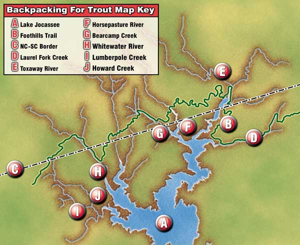
The reason is simple. Thanks to the sprawling reaches of the Sumter National Forest, particularly in the rugged terrain surrounding Lake Jocassee on the fall line along the North Carolina-South Carolina border, it is possible for the intrepid angler to escape, in delightful fashion, from the hurly-burly of today’s fast-paced world.
The delight comes in part from the solitude, but it also involves wading clear, rushing streams and casting to wild trout. Mind you, access isn’t easy, but then it never is when you seek to get away from it all. To access such fishing, it is necessary to make a backpack your temporary home and take to the trail. Simple, satisfying, and rewarding, this is a facet of the Palmetto State fishing scene available to anyone with what Grandpa Joe used to call “guts and gumption.”
Here’s a peek at taking to the backpack trail for trout-fishing success.
A master of this genre is long-time fly-fishing enthusiast Bill Lemke. Although he lives across the border in Hendersonville, N.C., Lemke has for many years heeded to call of the backpack trail to trout in both Carolinas.
Indeed, he shared thoughts about a long trip on the Foothills Trail, which has access to streams along the North Carolina-South Carolina border that beckon invitingly. There are other places in the Palmetto State high country that do the same, and with planning and sensible preparation, a trout fisherman can escape to backcountry angling where he is unlikely to encounter many others.
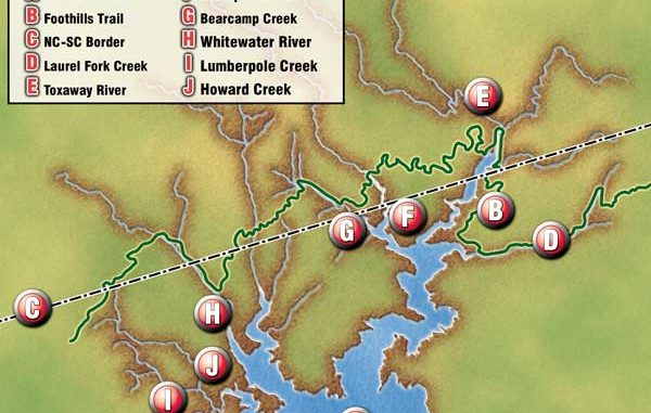
Many of South Carolina’s off-the-beaten-path trout destinations are accessed via the Foothills Trail, which hikers fondly refer to as “South Carolina’s Appalachian Trail.” Encompassing close to 100 miles, with another 100 in connectors, these are pathways to waterways.
The trails weren’t built with fisherman in mind, but they are a real bonanza to the angler. Those who explore these trails do need to be aware that the Foothills Trail wends its may along the North Carolina-South Carolina line, and most of the streams it crosses originate in North Carolina. With that in mind, it isn’t a bad idea to have a fishing license for both states in your possession.
Also note that camping regulations vary. For example, no backcountry camping is allowed in either Oconee or Caesars Head State Parks, and the same is true for the Whitewater River Gorge. But you still have options aplenty, and advance planning will let you know where you can (and cannot) camp.
Familiarity with some of the area’s most appealing destinations might help. Lemke visited many of these, and he makes a point well worthy of every serious angler’s attention.
“Some of the real fun of backcountry fishing involves the process of discovery,” he said. “I love to check out small feeder streams, especially those where the creek is your trail. It may require some sneaking and peeking, along with precision casting, but rewards come in the form of finding fish where others seldom go.”
The Whitewater River, reached via a short trail which begins at Duke Power’s Bad Creek Project and connects with the Foothills Trail, might be a good starting point. The stream is crossed by a foot bridge that provides an access point from which you can work upstream or down. Alternatively — and this applies to the Thompson River, Howard Creek, and Laurel Fork Creek as well — you can travel by boat across Lake Jocassee to the mouth of these streams. One major problem with that approach, although the nimble-footed can overcome it, is that most empty into the lake in precipitous fashion. It is recommended only for the young and fit.
Only a couple of miles of the Whitewater’s flow are in South Carolina. The stream is home to both browns and rainbows, but wild browns are its hallmark. The river’s mixture of deep plunge pools, runs, and riffles forms ideal habitat.
While the Whitewater River lives up to its name in appearance and features spectacular waterfalls, the Thompson River is South Carolina’s most remote “big” water. In truth, it is only a medium to medium-large trout stream by southern Appalachian standards, and elsewhere, it might be called a creek. But the Thompson is so rugged and remote it somehow seems larger and more impressive.
To reach this stream, which holds almost exclusively brown trout, requires a lengthy hike along the Foothills Trail. Its lower reaches are a classic gorge-type drainage, and you shouldn’t fish this area alone. Just a mile of the Thompson River lies in South Carolina, but if you have a North Carolina license, you can continue upstream.
Howard Creek, which empties into Lake Jocassee not far from Devil’s Fork State Park, can be reached by boat, trail, or, in its upper reaches, off Highway 130. It splits not far upstream from its confluence with Lake Jocassee, and two feeders, Corbin and Limberpole creeks, are also noteworthy. This is classic small-stream fishing, with plenty of tight canopy but also some relatively open water. Current regulations have Howard Creek and its major feeders closed during cold weather, but you’ll find it a wonderful destination for wild trout during ideal camping months.
Laurel Fork Creek flows into the Toxaway River arm of Lake Jocassee and might well rank as South Carolina’s most remote trout stream. Its entire drainage is designated “trout-natural” water by the state. You’ll find bigger trout in the lower end, below the falls, but don’t overlook the headwaters and feeders. A suspension bridge along the Foothills Trail crosses the stream, but it’s a demanding hike of more than eight miles from the trailhead. The trailhead is reached from US 178. Turn onto Laurel Valley Road (Pickens Co. Road S-237) and drive to the Laurel Valley Access parking lot. From there, you’ve got plenty of trail ahead of you.
Another noteworthy stream with headwaters in the Jocassee Gorges area is the Eastatoe River, but it does not feed Lake Jocassee. Much of the Eastatoe is readily accessible, but not so the steep headwaters gorge where the stream takes on size and strength. It really isn’t a river here, but rather a decent-sized mountain creek. It is feasible for a one-day trip, but camping makes better sense.
To gain access to the gorge area, you hike in from the Laurel Valley parking area reached from Highway 178 (Moorefield Memorial Highway) near the North Carolina border. A comparatively easy hike of 2½ miles along a blaze-marked trail takes you to the river. The maintained path ends here, but there is a readily discernible angler’s path along the right side of the stream. This is mainly wild-rainbow water.
These are but a sampling of the streams that might invite the camping angler’s attention, and a good session with topo maps will reveal more. As a general rule of thumb, any drainage longer than three miles at an elevation of 2,000 feet or more merits attention. If you discover one of those little secrets we all cherish, one offering tight lines and fine times, you will know the ultimate appeal of taking to the backpacking trail.
• • • • • • • • •
Jim Casada’s “Pursuit of Passion: An Insider’s Guide to Fly Fishing in the Great Smoky Mountains National Park,” will appear later this year. For more information, go to www.jimcasadaoutdoors.com).

Be the first to comment