


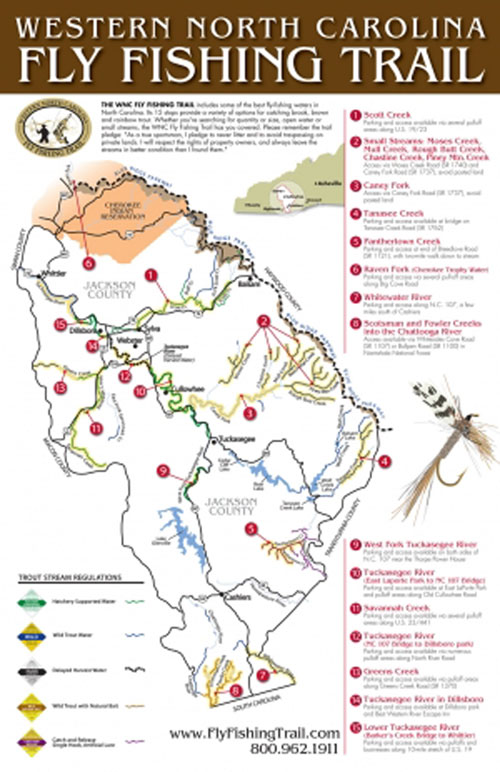
Parts of 15 streams are highlighted on Trail, the only one of its kind in the U.S.
With summer approaching, where does a fisherman go to beat the heat? Want to go somewhere a little cooler where you can fish a lot of different places without driving too far?
The Western North Carolina Fly Fishing Trail (WNCFFT) fills the bill, with 15 prime fishing spots for brook, brown and rainbow trout, plus a bonus of smallmouth bass and other fish. It offers a variety of waters from small streams to large open rivers, stocked in some cases from March through November.
Jackson County is the home of the WNCFFT, the first and only fly fishing trail in the country, which features some of the best trout fishing water in North Carolina’s mountains.
The idea for the Trail came from Alex Bell, who owns and operates AB’s Fly Fishing Guide Service and Jackson County native Bobby Kilby; the Jackson County Tourism Authority joined the fun early on, realizing it needed something to replace the Great Smokey Mountain Railroad during the 2009 downturn in the local economy.
Waters on the Trail include portions of four rivers — the Tuckasegee, Chattooga, Whitewater and Raven Fork trophy water in the Cherokee Indian Reservation — plus several small streams and remote waterways, including Tanasee and Greens creeks in the scenic Natahala National Forest, and Panthertown Creek, which bisects Panthertown Valley, aka the “Yosemite of the East.”
Streams on the Trail are in all corners of Jackson County, from the Raven Fork along the northern edge to the Chattooga and Whitewater rivers along the South Carolina border. Cities along the trail are Whittier, Dillsboro, Sylva, Webster, Balsam, Cullowhee, Tuckasegee and Cashiers.
Most of the streams have easy access and are close to major roads. Generally, access to the water is not more than 100 yards. The streams are regulated as hatchery supported, wild trout, delayed harvest, wild trout/natural bait, catch-and- release and artificial-bait only.
Here they are:
• Scott Creek is a 10-mile stretch of water that runs from its headwaters near Balsam downstream to Sylvia. The stretch also includes North Fork Scott Creek and Bluff Creek, which are very scenic.
Parking and access points with pull-off areas are available along US 19/23. The water is hatchery supported and has a good population of brown and rainbow trout. This is a small creek for small, dry flies, hoppers and stoneflies.
• Moses, Mull, Rough Butt, Chastine and Piney Mountain are a collection of small creeks below the Blue Ridge Parkway in the eastern part of the county. They course through mounatinous terrain that includes several large waterfalls. The access points include Moses Creek Rd. (SR 1740) and Caney Fork Rd. (SR 1737). This water includes rainbow trout in good numbers and wild brook trout in the Nantahala Natural Forest, but it also includes some private land that should be avoided.
• Caney Fork is roughly 10 miles long from East Laporte Park in Cullowhee to the headwaters at the junction of Mull Creek and Piney Mountain Creek. Access is from Caney Fork Rd. (SR 1737). This is undesignated water with good numbers of brown, rainbow and some brook trout. A lot of land along this stretch, however, is posted and private property.
• Tanasee Creek is roughly two to three miles long from its headwaters downstream to Tanasee Creek Bridge, which is a prime access point on Tanasee Creek Road (SR 1762). This water features wild brown trout in good amounts and size.
• Panthertown Creek is roughly a three-mile stretch of stream with parking and access at the end of Breedlove Rd. (SR1121), with a two-mile walk to the creek. This area is managed under catch-and-release, single-hook artificial lures only restrictions, with good quantities of brook trout.
• Raven Fork (Cherokee Trophy Water) starts at the Blue Ridge Parkway bridge and runs north for more than two miles. Parking and access points are available at several pull-off areas along Big Cove Rd., with foot paths that run along the stream. Most areas will have a sign at the pull off, and it is usually a short walk to the water.
This is catch-and-release, fly-fishing only water with good numbers and size of brook, brown, Donaldson, golden, and rainbow trout, with fish over 20 inches common. This stream requires special permits from the Cherokee Indian Reservation.
• Whitewater River runs between two and three miles from NC 107 to the South Carolina state line, with parking and access along NC 107 a few miles south of Cashiers. This section features good numbers of wild brown, brook and rainbow trout. These waters flow into Whitewater Falls, the highest waterfall east of the Mississippi River.
• Scotsman and Fowler creeks contain two to three miles of water flowing into the Chattooga River, with access available by Whiteside Cove Rd. (SR 1107) or Bullpen Rd. (SR 1100) in the Nantahala National Forest. These creeks feature wild brown and rainbow trout in good numbers, plus sizable fish in the Chattooga River proper.
• West Fork Tuckasegee River runs from the tailrace below Glenville (Thorpe) Lake for several miles yards. Parking and access are available on both sides of NC 107 near the dam. This stretch has hatchery supported brown and rainbow trout, with a concentration of stream-raised fish that will average between 12 and 15 inches.
• Tuskasegee River No. 1 runs two to three miles from East Laporte Park in Cullowhee to the NC 107 Bridge, with access available at the park and pull-off areas along the Old Cullowhee Rd. East Laporte Park has picnic tables and public rest rooms. This river features large numbers of hatchery supported brook, brown and rainbow trout.
• Savannah Creek is about 10 miles from the headwaters in Pumpkintown to the Tuckasegee River. Parking is available with several pull-off along US 23/44, but with limited access near the Tuckasegee. This stretch is hatchery supported with brown and rainbow trout in good numbers and is good for dry flies like parachutes, stoneflies and small hoppers.
• Tuckasgee River No. 2 is a four- to five-mile stretch from the NC 107 Bridge to Dillsboro Park. Parking and access is available with numerous pull-off along the North River Rd. This is delayed harvest water that offers the best place to achieve the Tuckasegee Slam — brown, brook, and rainbow trout — with good size and quantities.
The delayed-harvest regulations run from Oct. 1 until the first Saturday in June, with only single-hook, artificial lures allowed. The stream stocked from October thru May with approximately 50,000 trout that average 12 to 14 inches, with some in the 20- to 27-inch range. This a large stream that one can wade easily as well as float.
• Greens Creek extends three to four miles from the Macon County line to Savannah Creek, with access points along Greens Creek Rd. (SR 1370); it includes some posted land. Portions of the creek flow through the Nantahala National Forest. This is a small stream with limited access that supports wild trout, undesignated hatchery supported rainbow and some brown trout.
• Tuckasegee River No. 3 covers about a mile from Dillsboro Park through Dillsboro. These are hatchery supported brown and rainbow trout of good size.
• Lower Tuckasegee River extends eight to 10 miles from Baker’s Creek Bridge to Whittier, with parking and access along US 19. This section is hatchery supported, undesignated and has good numbers and sizes of brown and rainbow trout, plus, it’s home to some nice smallmouth bass. The last two sections of the Tuckasegee include some big-water float trips for smallmouth bass, rainbown trout and red-eye or rock bass.
DESTINATION INFORMATION
HOW TO GET THERE/WHEN TO GO: Jackson County is approximately 45 miles west of Asheville, with Sylva the county seat. Best vehicular access is from US 74, the Smokey Mountain Expressway, also US 441/23 from Franklin, NC 107 from Cashiers and US 19 from Waynesville through Maggie Valley to Cherokee. Trout fishing along the Western North Carolina Fly Fishing Trail in Jackson County is good year-round.
FISHING INFO/GUIDES: AB’s Fly Guide Service, 828-226-3833 or www.abfish.org; Brookings’ Cashiers Village Outfitters, 828-743-3768 or www.Brookingsonline.com; Hooker’s Fly Shop & Guide Service, Sylva, 828-587-4665 or www.hookersflyshop.com. See also Guides and Charters in Classifieds.
ACCOMMODATIONS: Best Western Plus River Escape Inn & Suites, Dillsboro, 828-586-6060 or www.bwriverescape.com; Carefree RV Resorts’ Fort Tatham RV Park 828-586-6662 or http://www.carefreervresorts.com/rv-parks/north-carolina/fort-tatham/; High Hampton Inn & Country Club, 800-334-2551 or www.HighHamptonInn.com; Smokey Mountain Getaways, 866-586-8058 or http://smokymtngetaways.net/; Sylva Inn, 828-586-3115 or www.sylvainn.com.
MAPS: Jackson County Tourism, 800-962-1911 or www.flyfishingtrail.com; N.C. Wildlife Resources Commission, www.ncwildlife.org/Fishing/TroutFishingMaps.aspx
Be the first to comment