


Locate deep-water brush piles and other crappie-holding structure and Lake Norman will produce some great slabs.
Today’s electronic technology has made searching for crappie easier than ever before. The latest innovations open up a new world to crappie fishermen, giving them underwater eyes to locate fish-holding cover far from shore in a quick and efficient manner.
Years ago, finding crappie meant targeting visible brush piles, planting brush piles around piers or lining up planted brush by painting trees or using triangulation. Some anglers just fished bridges.
These efforts paid off during the spring and fall crappie runs when the majority of fish remained in the shallows, but during the summer and winter when the fish moved deep, crappie fishing came to a standstill. Fishermen often called it a season and put away their bobbers and jigs until the next run on crappie.
Innovative techniques, including spider-rigging and slow-trolling with multiple rods, made the old cane pole and bobber almost obsolete and helped fishermen catch more fish but searching for crappie still was time-consuming.
The conventional depth finder could only display about one-third of what was directly beneath the boat, and its two-dimensional images could be mistaken for other things plus electrical interference and debris in the water added to the confusion. Searching for fish and fish-holding cover meant making numerous passes over open water in hopes of stumbling across them.
The new technology makes it impossible for crappie to disappear, thereby expanding the fishing season to year-round, including the winter if fishermen can withstand the cold.
Better yet, searching for fish and fish-holding features has never been easier with the development of side-imaging and down-imaging in conjunction with GPS capabilities.
These units can display fish and fish-holding features to the left and right of a boat as well as beneath it. Suspended crappie lingering over brush or crappie wedged between tree limbs all can be detected.
Fishermen can now create “milk runs” to fish and fish-holding features using waypoints, so they don’t have to search for the same places again.
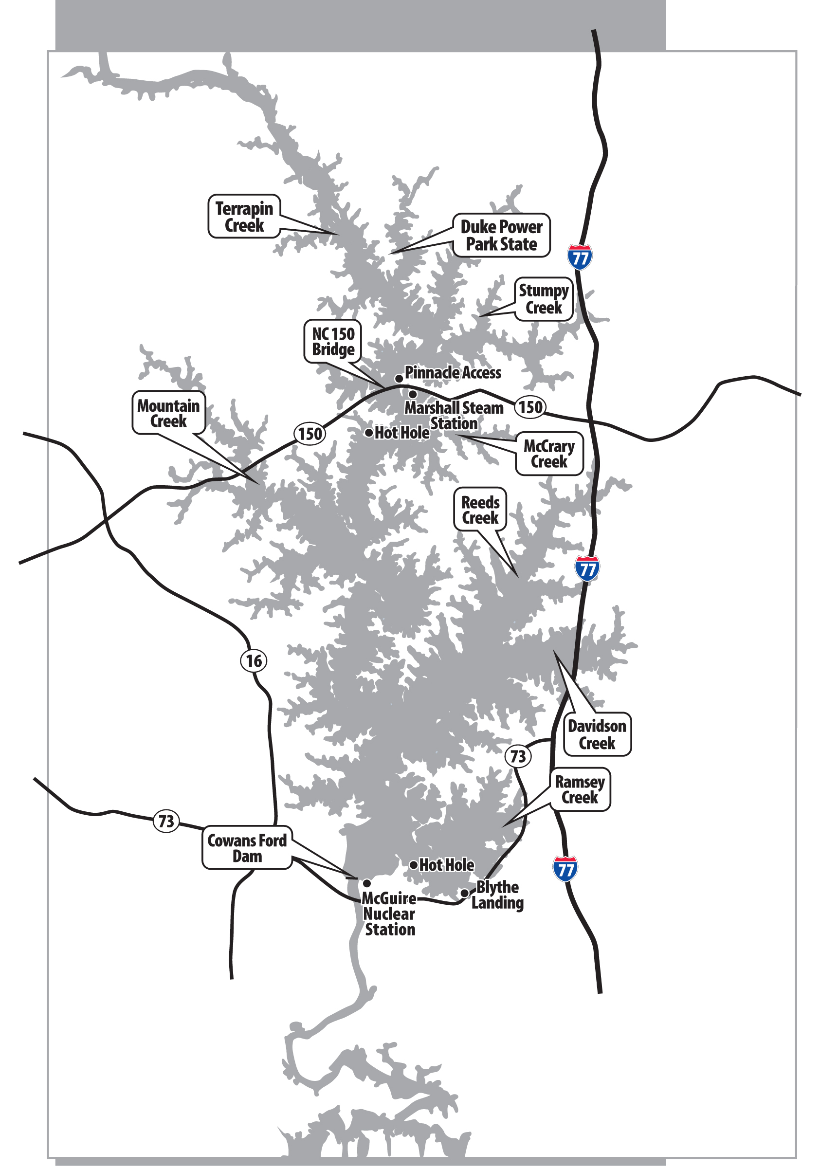
One reservoir where winter crappie fishing has exploded in recent years — and where a good set of “underwater eyes” can make a huge difference — is Lake Norman, the 32,500-acre Catawba River lake northwest of Charlotte.
“Norman wasn’t much of a lake for crappie until about eight or 10 years ago when the N.C. Wildlife Resources Commission implemented an 8-inch size limit and 20-fish creel limit on Norman,” said guide Gus Gustafson of Lake Norman Ventures.
“After the regulations went into effect, the crappie fishing has improved dramatically, not so much in terms of the fish count but more in terms of fish growth.
“Norman has never had the numbers of crappie like High Rock or hefty crappie like Badin. Instead, its fish have increased greatly in length, with plenty of crappie in the 15- to 16-inch range and a good number reaching 17 to 18 inches.
“With the advances in technology, crappie can be caught at Norman throughout the winter and at places and depths like never before.”
Gustafson’s electronics consist of two units, one with side-imaging and GPS and the other with deep-imaging and sonar. Used in conjunction, Gustafson can quickly find deep-water cover, even on a lake as large as Norman. He has marked more than 100 brush piles and trees in 15 to 25 feet of water with GPS waypoints — most of them in the middle of nowhere.
For fishermen unfamiliar with Norman, Gustafson said they should begin their deep-water searching at home by studying a topographic map of the lake’s bottom structure, then go out and use their electronics to find those places and mark them with GPS waypoints.
To find deep brush piles, Gustafson said fishermen should search the sections of the lake with older, more established neighborhoods along the shorelines, like this in Hagers and Mountain creeks. Long-time residents have planted brush in front of many of their docks, about the length of a cast away from the actual wooden structure. Docks featuring rod holders, rods, and lights are likely to have brush nearby.
The search should also include the deep side of creeks, where sunken brush and laydowns may exist in 15 to 20 feet of water. While searching, units with side-imaging can scan for brush and trees.
“Pretend a football field is covered with water, and your boat is at the 50-yard line,” said Fuzzy Lambert of Humminbird Electronics.“ With side-imaging, you can see what’s beneath the water all the way to each goal post at the opposite ends of the field.
“Imagine how long it would take a fisherman using conventional sonar to go from sideline to sideline all the way up and down the field to discover what’s there, since he’s limited to viewing objects directly in his path.
“With side-imaging, once you see brush or a tree, even if it’s yards away, you can mark it with a GPS waypoint and come back to fish it later without ever having been to the brush itself.”
Once he’s over brush, Gustafson uses down-imaging which gives a snapshot representation of the brush rather than the usual sonar 2D view.
“With down-imaging, there’s no question about what your seeing; brush looks like brush,” said Gustafson. “With sonar, you can’t always tell what you’re looking at. Down-imaging also enables fishermen to see fish between the branches of trees and fish suspended over brush.”
Once the electronic search of a creek is complete with GPS waypoints marking the spots, Gustafson can motor from brush to brush and fish each one.
Other waters worth searching in January are the back of Reeds Creek at the lower end of the lake and the Duke State Park area and Terrapin Creek at the upper end of the lake.
Gustafson ignores the mid-lake area because it the shoreline is mostly new homes with docks owned by recreational boaters who don’t fish much and don’t plant much brush.
Gustafson said it’s foolish to run from one end of the lake to the other in cold weather to conduct searches. Fishermen should target a specific area near a boat landing and confine their search to that area.
He also offers these tips for using electronics of any kind.
“Turn off the Fish ID and never use it,” said Gustafson. “The Fish ID enhances what it comes across and often converts leaves, debris, thermocline, and turbidity into fish symbols. You’ll waste a lot of time fishing for false images.”
With the Fish ID off, anglers can see fish arches and baitfish — things they want to see. Next, Gustafson said to leave the original factory settings of the unit alone. They’re set for maximum efficiency for most situations. Resetting the unit will not cancel existing waypoints.
“The first thing most fishermen do when they buy a new unit is to start pushing all the buttons without knowing what they’re doing,” sad Gustafson. “I never adjust the sensitivity or the speed of the unit. I use the unit just as it comes out of the box. The only functions I use are zoom-in or zoom-out because those functions don’t affect other settings. Leave the unit on automatic.”
Finally, anglers should take advantage of the technical support offered by manufacturers.
“These new units can be intimidating,” said Gustafson. “Lowrance and Humminbird offer toll-free numbers that fishermen can call, even if they’re out on the lake. The technician can provide on-the-water assistance to get the unit to do what the fisherman wants it to do. Don’t call around the busy holidays.
“Fishermen can get comfortable using their units if they fish with someone who will run them through the steps.”
Fishermen with basic sonar or without any electronics can find places to fish in the winter as well, though they’re limited.
“Make a cast out from old docks wherever you find them because they often have brush in front of them,” said Gustafson. “Fish steep banks with visible laydowns extending into deepwater.
“If you know nothing about the lake, always begin and end fishing the bridges for crappie. For some reason, crappie relate to bridges and suspend near the abutments. They may be shallow or deep, so fish depths from 15 to 50 feet.”
With the search complete, it’s time to go fishing.
In January, two techniques are used: tightlining with 1/16- or 1/32-ounce jigs on light line or tight-lining with minnows.
“The lighter the jig, the better, and the slower you move it up and down, the better,” said Gustafson. “Crappie are sluggish in January, so don’t snatch and jerk the jig. Keep in contact with the jig on its way down. Most strikes occur with the bait on the fall.
“Use a loose drag and don’t set the hook hard. Crappie have a paper mouth, and the hook can tear out. Fish slow and easy for crappie.”
Gustafson said crappie shut down when the water temperature drops into the 40s, but fishing rarely ceases at Norman because of the “hot hole” effect.
Norman has two hot holes: the Marshall Steam Station above the NC 150 bridge at mid-lake and the McGuire Nuclear Station just west of Cowans Ford Dam on the lower end of the lake. According to Gustafson, the warm-water discharges in the hot holes can raise the water temperature as much as 10 degrees in nearby creeks, which draws baitfish and keeps predators active.
McCrary Creek at the upper end and Ramsey Creek at the lower end are influenced by the hot holes, and they are the places to fish should water temperatures plummet elsewhere.
Given the new technology to enhance their searches, fishermen may find winter crappie fishing at Norman electrifying instead of numbing.
DESTINATION INFORMATION
HOW TO GET THERE — Lake Norman is north of Charlotte, within easy reach of I-77. NC 150 bisects the 32,500-acre impoundment west of Mooresville, with the Pinnacle and McCrary access areas off NC 150 on the east side of the lake. On the west side, Midway Marina is just south of the bridge. On the lower end of the lake, Blythe Landing off US 74 on Ramsey Creek offers convenient access.
WHEN TO GO — The spring and fall are prime months for crappie, but today’s technology expands the fishing opportunities into the winter months as well. In January, the fishing pressure is limited, and the recreational boating crowd is at home sitting in front of the fireplace.
FINDING/CATCHING FISH — Target brush, laydowns and old docks; Hagers, Reeds, Mountain and Terrapin creeks are prime areas, as are Lake Norman’s two warm-water discharges the Marshall Steam Station on the west side of the lake downstream from the NC 150 bridge and the McGuire Nuclear Station on Ramsey Creek. Tight-lining with light jigs and live minnows is the ticket to catch crappie. The lighter the jig and line, the better.
FISHING INFO/GUIDES — Midway Marina, 704-478-2333; Gus Gustafson, Lake Norman Ventures, 704-617-6812. See also Guides and Charters in Classifieds.
ACCOMMODATIONS — Mooresville Convention and Visitors Bureau, www.racecityusa.org; Go Lake Norman, www.golakenorman.com; www.visitlakenorman.org.
MAPS — FHS Maps, 800-ALL-MAPS; Kingfisher Maps, 800-326-0257, www.kfmaps.com.
Be the first to comment