


The three ‘faces’ of the Nantahala River offer trout fishermen different options for angling enjoyment.
Loosely translated from the Cherokee, Nantahala means “land of the noon-day sun.” The descriptive place name is apt, because over much of its flow, and especially in the gorge marking its lower reaches, sunshine reaches the Nantahala River for only a few hours each day.
Striking topography is but one of Nantahala’s many unusual and noteworthy features. Its lower reaches become a world-class whitewater destination when roaring waters from Aquone Lake, many miles away, are being released.
It is the only trout stream in North Carolina where night fishing is permitted — in the section downstream from the powerhouse. That portion of the Nantahala between the dam and power-plant outflow is arguably the state’s finest delayed-harvest water. Upstream of the dam, one of North Carolina’s oldest and most exclusive fishing clubs, the Rainbow Springs Club, controls an intensively managed, off-limits section of the stream.
Most interesting of all, at least from the fisherman’s perspective, is that public sections of the Nantahala River present three distinctive faces, encompassing many miles of fine trout water. In a sense Nantahala is “a watery schizophrenic.”
Those three faces are, moving upstream in sequence:
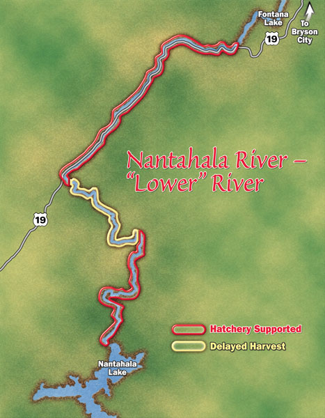
• The tailwater section between the powerhouse just off US 19 and the Nantahala’s confluence with Fontana Lake;
• The section downstream of the dam to the power plant outflow;
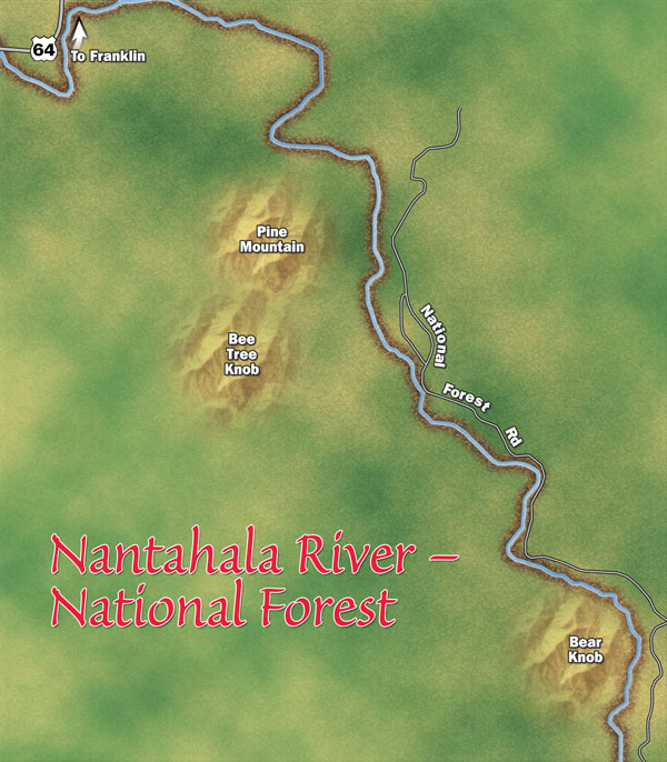
• The lengthy headwaters section in Standing Indian Game Lands of the Nantahala National Forest.
The three sections differ dramatically, and to add a bit of spice to what is already a tempting brew of varying trout opportunities, the Nantahala’s lower portion fishes quite differently according to whether or not the water is, to use local parlance, “on” or “off.”
Unlike the vast majority of trout-holding tailwaters — where the current is so strong when power is being generated that wading is impossible — you can, with due care and by picking your spots, actually fish the whitewater section even when the current is “on” and running full bore.
Thus, the Nantahala offers in the span of a single drainage, three distinctly different trout-fishing opportunities, with one of those three actually having two faces in its own right.
Years ago, the late Frank Young, as fine a trout fisherman as North Carolina’s high country ever produced, summed up the Nantahala’s many moods and varying nature quite nicely. “I’ve fished all over these mountains, and if I had to have a mess of trout or wanted to be guaranteed a good time, I’d take the lower Nantahala,” he said. “And if I wanted to get away from people while enjoying some mighty fine wild-trout water, I couldn’t do much better that the upper sections of the stream in the Standing Indian area.”
This praise of two faces of the Nantahala, coming from a man who returned home from the Korean War and fished an average of 250 days annually until heart trouble slowed him in his final years, speaks volumes.
The lower Nantahala is hatchery-supported water, receiving some of the heaviest annual stockings of any stream with this classification in the state. Yet it is also home to naturally reproducing rainbows and browns, and experienced fishermen will consistently catch four or five wild fish for every stocker brought to the net.
The tailwater produces hefty rainbows in the 10- to 13-inch range in great numbers, and with each passing year, brown trout become a bigger part of the overall population; some of the latter grow to lunker size. Access is the essence of simplicity, thanks to the fact that from Wesser Creek Falls all the way to the outflow at the powerhouse, US 19 is never more than 100 yards or so away from the river.
Most fishing in the gorge is done when the water is “off” — no outflow at the power plant — but local anglers have long realized that with care, it is possible to fish when the water is “on.” They wade the shallow side of long pools, fish places where the stream splits around islands and stream’s-edge pockets away from the raging torrents of midstream.
In such conditions, the splendor of solitude vanishes completely, thanks to a non-stop “hatch” of canoes and kayaks drifting past, often with unwelcome comments, but veterans such as local guide Steve Claxton will tell you the fishing is actually better in “on” conditions. In fast-moving water, trout don’t have much time to examine a fly or lure, so you can get by with larger tippets and mistakes which will see fish turn away when the water is off.
The delayed-harvest section begins at the power-plant discharge canal and continues upstream to the confluence of Whiteoak Creek. Unlike the whitewater section, which is truly a river size-wise, this section is more of a mountain creek. It was chosen for the delayed-harvest program because its waters become too warm in the heart of the summer for predictable trout survival. That being said, it does hold some wild trout. Access to the this section is provided by SR 1310, which begins at US 19 where the turnoff to the power plant is located. The road closely follows the stream, twisting and turning while crossing several times, all the way up to Whiteoak Creek.
The delayed-harvest section is immensely popular during the fall, winter, and spring months, drawing anglers anxious to enjoy its catch-and-release action, which features thousands of trout stocked annually as waters began to cool in autumn. The stockings include a good number of trophy-sized brood fish, and there’s always a chance of hooking a 20-inch plus trout in this section.
Action switches from catch-and-release, barbless, single-hook-artificials-only regulations to more liberal hatchery-supported ones on the first Saturday in June. That’s trout Armageddon Day, and as a local once joked: “If you want a rock to stand on that day, you better bring your own.” Beginning last year, fishing is restricted to kids only until noon on changeover day.
Mac Brown, a veteran Swain County angler who has spent a lot of time fishing the Nantahala for his own enjoyment and as a guide, has special affection for delayed harvest.
“You can bring inexperienced fishermen here, and they have reasonable expectations of landing a number of trout,” he said. “Similarly, the highly skilled angler who enjoys catching lots of fish or the challenge of casting to a visible trophy fish made wary by having been caught repeatedly can have a ball. I’ve enjoy numerous days of 50 or more trout here.”
The third face of the Nantahala is found far upstream in Standing Indian Wildlife Management Area. This is traditional wild-trout water at its best. Portions of the stream, which has many feeder creeks also holding trout, are accessible by road. Take SR 1448 off US 64, and then turn onto National Forest Rd. 67 at Wallace Gap.
The Nantahala’s headwaters offer the tight cover, plunge pools and pockets typifying high-elevation trout streams throughout the mountains. Browns and ’bows share the water, and the uppermost reaches of some tributaries, contain brook trout — “specks” — as well. Among the more noteworthy feeders, mostly off trail, are Long Branch and Bearpen, Hurricane, Big Indian, Buck, Kimsey, Park, Curtis, and Kilby creeks.
This section of the Nantahala is a great area for backpacking fishermen who enjoy solitude. Where you have plenty of competition and roads at streamside on the other portions of the river, gravel roads give way to forest trails, and for many stream miles, no trails at all.
Taken in its entirety, Nantahala is a trout fisherman’s stream of dreams. It is probably the state’s finest, and certainly when it comes to variety it is in class by itself. One or the other of its faces offers something sure to appeal to any trout fisherman.
• • • • • • •
Editor’s Note: Jim Casada is a full-time freelance writer who grew up just a few miles from the Nantahala in Bryson City. He has just completed a book, “Pursuit of Passion: A Fly Fisherman’s Guide to the Great Smoky Mountains National Park.” For details, visit www.jimcasadaoutdoors.com.


Be the first to comment