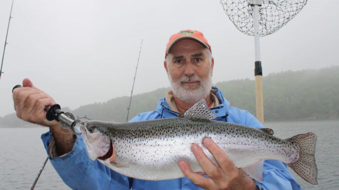
A mountain gem and home to a fine population of trout, Lake Jocassee serves up super April fishing. But in such a deep lake, where do you begin? Here are 10 great spots to get you started.
Sam Jones doesn’t know why trout relate to structural features that are 100 feet beneath them. More important than “why” they do, though, is knowing “that” they do so and learning which structures attract the most fish any given month.
Jones, who operates Jocassee Charters, has learned those lessons through longevity. He grew up fishing Upstate waters with his dad, has fished Lake Jocassee for 30 years and has guided for the past 10 years. Jones specialized in controlled-depth trolling for trout, and he often targets fish that suspend well above structural features.
Steep sided, extremely deep, clear and cool, Jocassee demands different approaches than do most South Carolina lakes. Making this lake even more distinctive, trout are its most-prevalent game fish. Rainbow and brown trout, which the S.C. Department of Natural Resources stock annually, cruise the lake’s open waters and feed on big schools of blueback herring and threadfin shad.
During April, the trout suspend in the water column; they might be 40 feet or more than 100 feet deep. Often, the bottom is another 100 feet beneath the fish, but they still relate to channel bends, creek confluences and other structure. Where treetops reach up to within 100 feet of the surface, trout often will hold among the branches.
“Your GPS and graph are your best friends on this lake,” Jones said. “You need to work over the structure, and you need to watch for baitfish and for trout as you go so you know how deep to run your baits.”
Lake Jocassee also produces very good bass fishing at times, again with an unusual species mix for South Carolina waters. The state-record smallmouth, spotted and redeye bass all came from Jocassee, and largemouth bass, though fairly small in number, grow to big sizes in these waters. Jones catches quite a few bass while he’s fishing, but he primarily targets trout by trolling spoons, plugs or live-bait offerings and using downriggers to provide depth control.
Here’s a look at 10 specific spots where Jones typically finds fish during April.
1 Dam Intakes
34 57 797 N/82 55 068 W
“It’s everybody’s morning spot from spring through fall,” Jones said of the hump just out from the water intakes at Jocassee Dam. “There will be at least a couple of boats there most mornings.”
Jones doesn’t mind a little company on this particular spot, though, because it usually produces fish and helps him get his day off to a good start. Duke Energy commonly back-pumps from Lake Keowee during the night and then runs water back through the dam during the day to generate power. Water flowing in either direction creates current in the intake area, and back-pumping tends to “chum” the water with chewed up baitfish from Lake Keowee.
Jones typically begins just out from one intake and trolls toward the other, crossing the hump between them along the way. He’ll troll back and forth, varying his distance out from the intakes and the depths of his lines and watching or fish on this graph.
Bass fishermen also do well in this area. They position their boats next to the buoy line that marks the limit to where they are permitted to travel and cast spoons and other shad-imitating lures directly to the intakes. Given good water movement, casting and cranking a spoon can produce anything from a redeye bass to a big brown trout.
2 Keowee River Channel
34 58 267 N/82 54 996 W
Lake Jocassee trout like to suspend over very deep water, and the lower Keowee River channel offers some seriously deep water. Jones has marked depths of 340 feet in places.
He will troll directly over the channel edge, working from the Toxaway/Whitewater confluence, where the Keowee River officially forms, all the way to the to the area in front of the rock quarry, where the channel makes a hard bend. He’ll catch fish throughout that stretch.
Most fish hold over bends in the channel or over underwater points at the mouths of inundated pockets, so he follows the channel edges closely and watches his trolling speed and depths extra closely whenever he crosses a point or the channel turns.
3 Spillway Area
34 57 556 N/82 55 868 W
Staying in the extreme lower lake, Jones also catches a lot of trout from a broad, deep flat directly out from Lake Jocassee’s spillway. Jones likes to keep his boat over approximately 200 feet of water. However, if he doesn’t catch fish at that depth, he’ll move a little closer and try a slightly shallower pass.
The area in front of the spillway has a lot of submerged trees, and the tops of the trees hold big numbers of trout. If Jones doesn’t mark fish suspended in the water column, he’ll set his downriggers to run baits barely over the treetops. The trees tend to hide the fish from the graph, so he often doesn’t know that “tree fish” are even around until one takes a lure. Isolated ditches that break up the flat and the trees are especially productive.
4 Jumping-Off-Rock/Toxaway River
35 00 606 N/82 54 757 W
Just out from Jumping-Off Rock, a famous Lake Jocassee overlook from which postcard are photos often shot, the Toxaway River goes through a large and well-defined S-turn, and the trout congregate in both channel bends. A couple of ditch confluences provide additional fish-holding structure in the same area, and plentiful submerged trees add trout-holding cover.
Jones trolls this entire area, pulling baits along the edges of the river bends and over the tops of the ditches. In order to catch fish, he sometimes has to stay busy working the downriggers. Some tree are 100 feet below the surface, while others top out only 40 feet down, and the baits often must be swimming just above the tops of the trees to draw strikes.
“A lot guys also bass fish along the bank in this area and do well,” Jones said.
5 Three Rivers
35 01 787 N/82 55 022 W
Moving farther up the Toxaway River arm, the Three Rivers area of Lake Jocassee stands out as a “money spot” for trolling anglers in tournaments and a hotspot for night fishing during the summer due to an outstanding complex of structure and the deep water that is available in the main-river channel. Laurel Fork Creek and the Horsepasture River join forces with the Toxaway River roughly 500 yards apart, and both tributaries enter the main river within hard bends in opposite direction.
Despite being well up the lake, where the water doesn’t tend to be quite as deep overall, the Toxaway channel is nearly 200 feet deep within the river bends. Jones works the entire Three Rivers area thoroughly, knowing the fish might be over the inside or outside edge of either bend, atop the points at the confluences or along the Toxaway channel edge between to two confluences.
Depending on the amount of wind and the depth they want to fish, night fishermen either drift slowly across the area or move shallow enough that they are able to place an anchor. In either case, most put down a floating light, like a crappie fisherman would use, and fish night crawlers or minnows on tight lines off the side of the boat.
6 Bearcamp Creek
35 02 356 N/82 56 165 W
The waterfall embayment in Bearcamp Creek offers an outstanding place to get out of the wind, catch fish and enjoy Lake Jocassee at its best.
“Once when I was back there, I saw a deer jump in the water and start swimming. About that time, one of my rods popped up, and we caught a big rainbow. And as I was netting the fish, I looked up and saw a bald eagle flying overhead,” Jones said.
The waterfall is actually on Mill Creek, a Bearcamp Creek tributary that feeds it from the south in the center of a steep-sided cove. Bearcamp, a tributary of the Horsepasture River, offers deep water and always seems to hold baitfish. “Where you find baitfish, you find trout,” Jones said.
Jones generally will set his downriggers to pull spoons or live bait about 60 feet deep, and he’ll troll as far as he can go up Bearcamp Creek, then turn around and troll back to the mouth of the creek. The area around the waterfall is also a good place to set up at night for trout, he said.
7 Whitewater River Points
34 59 061 N/82 57 588 W
Moving around the long point that divides Lake Jocassee’s Toxaway and Whitewater River arms, a series of prominent points near the lower end of the Whitewater River arm tends to hold big numbers of trout. The fish relate to the edge of the inundated river and especially to the tops of the points, suspending directly over the structure.
Jones typically starts out with his baits fairly shallow (by Jocassee standards) pulling them about 40 feet beneath the surface. If the fish don’t cooperate, he sets the baits deeper — down to about 80 feet — and makes another pass, pulling the baits a little farther down the same points. The main channel of the Whitewater River is about 300 feet deep in this area, and often the trout will suspend directly over the drop into the deepest water.
8 Whitewater Falls Area
35 00 174 N/82 59 448 W
Moving well up the same river arm, almost to the point where Lower Whitewater Falls completes its plummet into the lake, the main Whitewater River channel near site of the Bad Creek project offers outstanding fish habitat. The main channel is 170 feet deep just downstream of the project site, but a rocky shelf rises to 35 feet.
Smallmouth and spotted bass hold atop the shelf and relate to its edges, while the trout concentrate in the main channel, especially on the downstream of side of the structure. Jones trolls in the main river channel, beginning downstream of the shelf and working toward it. As he approaches the structure, he’ll either bring his baits up substantially or he will turn and continue trolling in the opposite direction.
Sometimes-strong currents and high dissolved-oxygen levels add value for gamefish and their forage; rip-rap and a concrete structure add shoreline cover; and ever-present floating trash provides both shade and cover, especially for the bass. The trash collects in eddies, and the bass watch for foodstuff to be swept past in the current.
9 Devils Fork
34 58 614 N/82 58 748 W
Devils Fork, the namesake for the state park on Lake Jocassee’s banks and the main public access to the lake, gets its name from the three tributaries that join forces to form the lake’s most westerly creek arm. Before the lake’s impoundment, Howard, Corbin and Bad creeks coming together and forming one larger stream presumably resembled a devil’s pitchfork in someone’s mind.
To trout, this multi-creek juncture simply looks like a fine place to swim and dine on abundant baitfish. Jones trolls over the main-creek channel, pulling baits both over the channel edges and over the middle of the channel. During the spring, he especially likes the edges. As the season progresses, the fish are more apt to hold over the very center of the creek channel.
10 Roundhouse Point
34 57 875 N/82 56 169 W
“We joke about them still growing,” Jones said, describing the submerged trees that stretch up from the bottom atop Roundhouse Point. “Some of them will get you when you’re trolling.”
Those same trees hold trout, though, and combine with the structure provided by the point itself to make this one of the most productive areas on Lake Jocassee. Current also pushes across this very prominent point any time water is running through the dam, and the fish tend to feed better when the water is running.
Jones’s strategy is simple He trolls back and forth across the point, varying his distance from the shore and paying attention to the bottom depth whenever he catches a fish or marks fish on his graph.
The point draws its name from a group of round houses that used to be on the shore. “Now it’s all big houses.” Jones said.
Sam Jones of Jocassee Charters can be contacted at 864-280-9056 or http://www.jocasseecharters.com/.

Be the first to comment