


Hunting by water offers plenty of opportunities
Although float trips have no season, the period from Thanksgiving through the end of the year is the perfect time to plan a trip with a buddy, put the kayak in the back of the truck and float a stretch of moving water. Typically, ducks are the preferred quarry, as the season opens during Thanksgiving week, closes for a few days when December arrives, then runs through the third week of January.
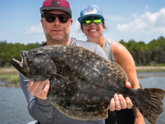
At the same time, the cooler weather makes many fish species — stripers, largemouth bass, redfish and trout, to name a few — more active, and they can be found moving into and around river systems.
Also not to be overlooked is the fact that it’s a lot easier and quieter to float into remote wooded areas than to walk in from a road, and the water side of most public lands are where the deer, hogs, squirrels and other game animals prefer to hang out anyway. Bear in mind that the hunting or shooting of most of these animals is prohibited directly from a watercraft, but paddling into the area to be hunted is not.
For waterfowl hunting, a float trip is ideal, as hunting can be done from the boat, and the boat itself makes an ideal floating or stationary blind, depending on how you elect to hunt. Ducks will flock to inland rivers and large creeks, and, if properly done, can be jump-shot by sneaking around corners or camouflaging the boat and drifting within range of rafting ducks and geese.
From Nov. 28 through December, just about any game animal that’s legal to hunt is fair game. Deer season with guns is open. Squirrel season spans that time, as do rabbits, foxes, raccoons and a host of fur-bearing animals. No matter what species you’re after, a quiet float down a stretch of creek or river can help you identify travel routes, food sources, bedding areas and even scout out specific animals just by being observant. When you spot what you’re after, it’s simple to beach the boat, slip into the woods and hunt.
If you haven’t fished a particular stretch of water since the spring, South Carolina’s higher-than-average rainfall through the spring and summer most-likely changed the underwater topography. Areas that were devoid of fish-holding cover may be replenished by floating logs and debris washed downstream and vice-versa. Shallow or shoal areas not conducive to floating can be waded by anglers who come equipped with a pair of hip or chest waders. Deeper pools or runs can be fished at anchor or on a stake-out pole, and never overlook the benefits of trolling at least one line, maybe free-lining a live bait while floating from one spot to the next.
For anglers and hunters who ply coastal waters with tidal influence, timing your float to take advantage of tidal movements can save a lot of paddling. Keep in mind that areas far inland from the coast may still rise and fall with tidal influences but may be several hours off schedule from coastal areas.
For inland, non-tidal floating, two obvious options exist for planning a float trip, and both involve multiple land vehicles. By studying a topo or on-line map, float-trippers can identify what stretches of water they want to run and what possible launch, porting and exit areas exist. A map that also includes public road access can suggest an area where a pick-up vehicle can be instructed to meet the floater or where two or more paddlers can park one vehicle, then circle back and launch boats upstream from another vehicle.
Public launch areas are the most logical areas to use for entrance and egress and the S.C. Department of Natural Resources website lists all public access areas at www.dnr.sc.gov/mlands/boatramp. Areas are listed both by body of water and county. In addition to these areas, many public transportation right-of-ways that traverse a river or creek may offer legal access to that water.
Once in the water, riparian rights govern what areas are accessible and which are not. Waters that are navigable by boat are generally considered to be public water. Adjacent landowners may have ownership of the shoreline and possibly the stream bed. Hunters who stay in the boat can avoid trespassing. Other areas may dictate that both land and water within the normal stream bed are open to public access. Check with local authorities before hunting a stretch of water to make sure you’re legal. Online maps of WMAs and other public hunting lands adjacent to navigable rivers can be found online at www.dnr.sc.gov/wma/maps.
Paddlers who frequent the Charleston area have a valuable resource available in terms of launch sites and tips in published form. The spiral-bound Kayak Charleston was written by Ralph Earhart, who logged more than 3,300 miles preparing the guide.
Though written by and for recreational paddlers, Kayak Charleston lays much of the groundwork for a successful sporting outing by suggesting put-in and take-out sites, maps, float times and even provides some GPS waypoints for navigation. The book is self-published and is available in many Lowcountry outfitter shops or online at kayakcharleston.net.


Be the first to comment