

Do you remember Loran? I’m surprised how many dedicated fishermen don’t, but you might want to take a few minutes and learn a little about the new version. I’m not talking about Loran-C — and certainly not about the real old-timer, Loran-A — but a thoroughly modern version named “enhanced Loran” or “eLoran.”It seems that after a few interruptions in the GPS signal, our national-security folks believe that eLoran might just be the best system to fill in the gaps caused by any interruptions in GPS.
Unfortunately, a number of politicians, including the president, don’t seem to see the need for a backup positioning system. However, there is some congressional concern, and continued funding for eLoran is currently being debated as a component of the 2010 Federal budget.
On May 12, an e-mail went out from the International Loran Association (www.loran.org) regarding the need for eLoran as a secondary means of maintaining the operation of precise position and timing information. This e-mail cited a study done by an Independent Assessment Team for the Institute for Defense Analyses (www.ida.org), headed by Dr. Brad Parkinson of Stanford University, who is generally considered to be the father of GPS.
The Department of Homeland Security (www.dhs.gov) agrees with the need for eLoran as a backup system. In a press release dated Feb. 7, 2008, the initiation of eLoran as that backup system was outlined.
The DHS press release read:
“Today, the U.S. Department of Homeland Security will begin implementing an independent national positioning, navigation and timing system that complements the Global Positioning System (GPS) in the event of an outage or disruption in service.”
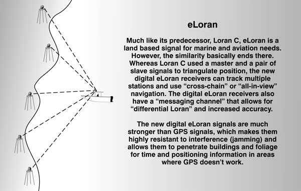
The enhanced Loran, or eLoran, system will be a land-based, independent system and will mitigate any safety, security, or economic effects of a GPS outage or disruption. GPS is a satellite-based system widely used for positioning, navigation, and timing. The eLoran system will be an enhanced and modernized version of Loran-C, long used by mariners and aviators and originally developed for civil marine use in coastal areas.
In addition to providing backup coverage, the signal strength and penetration capability of eLoran will provide support to first responders and other operators in environments that GPS cannot support, such as under heavy foliage, in some underground areas and in dense high-rise structures. The system will use modernized transmitting stations and an upgraded network.
This noted some concerns the ILA had with disruptions to the weaker GPS signals and a concern that GPS was only useable when the transmitting satellites were in view. With the difference in eLoran signals, they are available in situations that are not line-of-sight and in-clear-view and can provide timing and location information in situations and locations where GPS cannot.
While I fully support their efforts, I don’t always agree with DHS, but on this, I think they are spot-on correct. A loss of GPS signal for a few seconds isn’t a major problem for a ship steaming into port at 20 knots, but for an airliner on final approach at 250 knots, it could be a disaster. The potential for eLoran to aid first responders such as police, fire and rescue in inner-city locations also covers a shortcoming. In addition, it has been shown that eLoran has a stronger signal, rated 100,000 times more difficult to jam than GPS, and it has an accuracy of eight to 20 meters, which is only marginally less than GPS (and far superior to the original GPS when Selective Availability was being used).
In the eLoran report forwarded by Parkinson’s team, it was noted the status of eLoran showed the upgrades of existing infrastructure are about 70-percent complete. This was funded by Congressional appropriations totaling $159 million between 1997 and 2006. The most costly upgrades are to the transmitters; all 18 in the continental U.S. and two of the six in Alaska have been upgraded to eLoran. This enabled immediate staffing reductions and significant operations and maintenance savings.
The remaining eLoran work includes completing the Alaskan upgrades, adding new unstaffed differential monitors and upgraded time transfer systems, plus implementing four additional transmitters recommended in the continental U.S. Parkinson’s team compared the entire cost to complete the eLoran upgrades as equal to approximately half of the cost of one orbiting GPS satellite.
Costs are a factor. Parkinson’s team felt the initial costs of the new eLoran equipment would be offset in only a few years by significantly lower annual maintenance and operating costs. There was also some research into the cost of manufacturing eLoran receivers and the cost to the end user to purchase them.
Several manufacturers were polled, and the team worked with several college laboratories and came up with an initial cost of approximately $1,000 that would lower significantly as the numbers increased. The figure of $300 was prominent in their report as the increased cost of adding an eLoran receiver to a GPS unit. Their findings said the two receivers could operate simultaneously and offer seamless switching between the GPS and eLoran processes as needed.
I remember when GPS first became popular, differential receivers were required to offset the deviances inflicted by Selective Availability, there were a few units available that contained both GPS and Loran-C receivers. At that point, signals were significantly different, but it could still be done. It certainly should be easy enough to do now with eLoran having a digital signal and using a new small H-field antenna to eliminate static.
One unique thought expanded upon by the team was that since the eLoran signal is virtually unjammable, once it is in full operation, there would not be any attempts to jam the weaker GPS signals. That makes sense to me, too. Why would someone — a terrorist group, enemies, prankster or whatever — go to the trouble of jamming a signal if it wouldn’t create a significant disruption?
Parkinson’s team made four unanimous recommendations, with a couple of sub-provisions in each:
• Retain eLoran as the primary backup for critical GPS Applications;
• Fund completion of eLoran;
• Commit to 20 years of eLoran;
• Develop a funding plan for the completion of eLoran;
• Add differential sites for maritime and timing needs;
• Review alternatives for reducing costs in Alaska;
• Add transmitters for maritime and aviation use in the continental U.S.;
• Convert to unmanned model (as in Europe);
• Goal of $15 million annual operating costs;
• Stimulate receiver development and equipage;
• Integrate eLoran as backup within GPS receivers;
• Reduce costs through mass production;
• Consider regulation or incentives for equipage in key applications;
Several European countries have already committed to eLoran as a complimentary backup to GPS and Parkinson’s team felt the United States needed to commit to complete the coverage.
The Independent Assessment Team, the Dept. of Homeland Security, the International Loran Association and numerous other groups and individuals have provided to our Congressional leaders their support for eLoran as a functional backup to GPS.
For boaters, it offers the potential for a seamless backup to GPS, and as citizens, it offers the potential for better and quicker response by police, fire and rescue in urban settings and/or natural canyons when the necessary GPS satellites are not in view — plus the potential for prevention of transportation and security interruptions.
The eLoran program is being debated in Congress as part of the 2010 budget, and we have a chance to have our voices heard. Please contact your representatives and senators to let them know how you feel. You can find their contact information at www.congress.org. In the top tool bar, simply enter your zip code and click on the “Go” button. It will list your federal and state elected officials and how to contact them.
NOTE: While several manufacturers are working on eLoran receivers, Si-Tex (www.si-tex.com) is currently offering one integrated into an antenna, which plugs into their Navmate, COLORMAX Series, Trawlplot, and Explorer Plus Charting Systems and P-SEA Windplot II software. A quick check showed pricing that ranged from approximately 700 to 800 dollars.


Be the first to comment