
Capt. Davie Tilley of the Continental Shelf understands that many anglers opt to fish out of their own private vessels, but he is still willing to help them out through a service he offers called “Fish Here Maps.”
When planning his own fishing trips, Tilley observes wind, current and water temperature predictions for the day or days he will be fishing. He utilizes maps that show depths and breaks, then puts a plan together based on his past experience in those areas, along with National Weather Service and NOAA predictions for tide cycle, water temperatures, wind and currents.
Armed with this information, Tilley comes up with a number of likely areas to chose from, and he can’t fish them all. So instead of letting that information go to waste, he offers it to other anglers for $25. He emails the maps, along with detailed information of certain highlighted spots, to the angler the night before this trip.
Tilley doesn’t simply create generic maps and sell them to weekend anglers. He creates customized maps based on each angler’s desired species, which inlet he will leave from and the duration of their trip. He even uses the angler’s input, such as “I want to catch dolphin inside Marker 23.” His customers include seasoned anglers as well as novices.
Anglers can purchase these maps by visiting www.fryingpantower.com and clicking on the “Fish Here Maps” button, then filling out the necessary information.
Jeremy Clive of Pacolet, S.C., has utilized this service, and said he will again.
“The map was right on the money, and I saved more than $25 in fuel by heading straight to a productive spot,” he said.
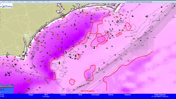
#1 Doorstep High (34 11.900 x 76 57.500 – Not Exact) Good Change in MLD and Sub-surface Temp. Lots of Seabass, Grouper, Should be broken weedlines with Mahi and Kings.
#2 Ledge (34 01.500 x 76 52.500 – not exact) Good Change in MLD. Should be broken Weedlines with Slinger Mahi and Kings.
#3 Ledge (34 03.920 x 77 00.500 – not exact) Sub surface Temp change. Bottom Fishing, Kings and Slinger Mahi.
#4 Between Steam Wreck (33 51.755 x 77 08.999 – not exact) and Riches Wreck (33 55.530 x 077 06.000 – not exact) This area has been alive now for several days. Good Mahi, Kings and a wahoo/sail or two.
#5 SE 23 Mile Rock (33 57.100 x 77 18.480 – not exact) Good Break and Weedlines. Mahi, Kings and maybe a Sail or two. My best spot for tomorrow.
#6 Hunters Hole (33 47.751 x 77 25.510 – not exact) Lots of broken Bottom in this area. Hold good bottom fishing this time of year;
#7 Devils Asshole (33 40.516 x 76 46.852 – not exact) I do not think much of the stream. It is pushed way offshore. This area is the best there is. Start inshore a few miles. Work out to the break and then south. You should find breaks and weedlines holding some decent Mahi. Doesn’t look like a barn-burner day, but you should be able to make a day of it.
Be the first to comment