

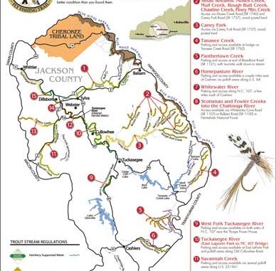
Jackson County in far western North Carolina is a land of mile-high mountains, cascading waterfalls, picturesque lakes, and hundreds of trout streams. The streams, large and small, are scattered throughout the 499 square miles within the county borders. With such a broad choice of fishing opportunities, selecting a suitable stream can be as much of a problem as deciding which dishes to sample at a sumptuous banquet. You can’t sample them all, but you do want to sample the best.A new guide allows fishers to sample some of Jackson County’s best streams. Promoted as the nation’s first “fly-fishing trail,” the Western North Carolina Fly Fishing Trail highlights portions of four rivers and more than 11 creeks, offering a wide choice of fishing experiences: wild-trout waters, hatchery-supported waters, delayed-harvest waters and catch-and-release artificial lures only.
The map gives precise stream locations, access points, information on parking, type of fishing, and length of the streams. Brochure-sized and printed on durable, water-resistant stock, the map can be stuffed in a back pocket or fishing vest for handy reference.
Although designated as a fly-fishing trail, other types of fishing are permitted, depending on state regulations for each stream.
The map points to these streams as noteworthy:
• Scott Creek: A stream often overlooked by fly-fishers, Scott Creek offers 10 miles of prime fly fishing from its headwaters near Balsam to downtown Sylva. While some sections are hatchery-supported, it has a fair to good population of wild trout in the upper reaches. Fishing-worthy tributaries also are listed.
• Tanasee Creek: Located partly in the Nantahala National Forest in eastern Jackson County, Tanasee is noted for its brown trout. It runs from two to three miles from the mouth of Tanasee Lake to its headwaters. The fishing is challenging, but rewarding.
• Panthertown Creek: A catch-and-release stream located in the Panthertown Valley in southeastern Jackson County, Panthertown Creek is noted for its large brook trout, some in the 12- to 14-inch range. This is not a park-and-fish stream. Access to the creek requires a 2-mile walk.
• Horsepasture River: Located east of Cashiers near the Transylvania County line, the Horsepasture has an excellent population of rainbow trout, some in the trophy range. The stream produced the state record rainbow trout — 20 pounds, 3 ounces — in January 2006.
• Tuckasegee River: From the bridge on NC 107 near Western Carolina University to the Dillsboro Dam, the stream is one of the top delayed-harvest streams in the state. It is the largest stream on the trail, and during the delayed-harvest season, one of the most-heavily stocked. Access to the stream is excellent all along North River and South River roads. It’s a place where most area guides take their customers. Four other sections of the Tuckasegee also are listed on the map.
The idea for the trail and map was conceived by Julie Spiro and Craig Distl of the Jackson County Travel and Tourism Authority, which produced and distributes the map.
Spiro said the goal was to help anglers identify prime places to fish without trespassing on private property. The map notes areas that are posted.
The trail itself was created by two veteran fly fishers, Alex Bell of Sylva and Bobby Kilby of Pawley’s Island, S.C. Bell, a retired educator, operates AB’s Fly Fishing Service in Sylva and has spent a large portion of his life fishing area streams. Kilby, a native of Western North Carolina, has the distinction of having fished and caught trout in more than 1,040 streams in western North Carolina.
A companion website to the map allows anglers to access trail information online and post photographs of their catches. Spiro said GPS coordinates of each stream will be posted by April 4, Opening Day of trout season on hatchery-supported streams.
The map is free for the asking. To receive one, anglers are asked to take a pledge to maintain the natural beauty of the trail and respect the rights of property owners, something anglers should be practicing without having to be asked.
Copies can be obtained by calling the Jackson County Chamber of Commerce at 800- 962-1911 or writing to the Jackson County Travel and Tourism Authority, 773 West Main Street, Sylva, NC 28779. A small version of the map is available on the Internet at www.FlyFishingTrail.com.


Be the first to comment