
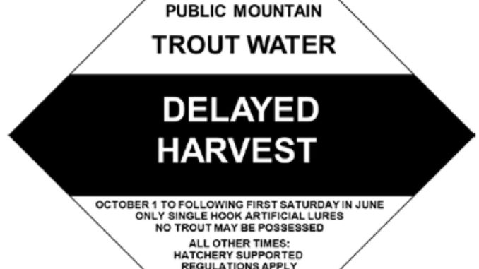
The following streams are in the N.C. Wildlife Resources Commission’s delayed-harvest program:
Alleghany County: Little River (Whitehead to 275 yards downstream of the intersection of SR 1128 and SR 1129;
Ashe County: Big Horse Creek (SR 1324 Bridge to North Fork New River), Helton Creek (Virginia state line to New River), South Fork New River (Todd Island Park), Trout Lake;
Burke County: Jacob Fork (Shinny Creek to lower South Mountains State Park boundary);
Caldwell County: Wilson Creek (game land portion below Lost Cove Creek to Phillips Branch);
Clay County: Fires Creek (USFS Road 340A to the foot bridge in the USFS Fires Creek Picnic Area);
Graham County: Big Snowbird Creek (USFS footbridge at the old railroad junction to USFS Road 2579);
Haywood County: West Fork Pigeon River (Queen Creek to the first game landboundary upstream of Lake Logan);
Henderson County: North Fork Mills River (game land portion below the Hendersonville watershed dam);
Jackson County: Tuckasegee River (downstream NC 107 bridge to the falls located 275 yards upstream of the US 23/441 bridge;
Macon County: Nantahala River (Whiteoak Creek to Nantahala hydropower discharge canal);
Madison County: Big Laurel Creek (NC 208 bridge to the US 25/70 bridge), Shelton Laurel Creek (NC 208 bridge at Belva to the confluence with Big Laurel Creek), Spring Creek (NC 209 bridge at Hot Springs city limits to iron bridge at end of Andrews Ave.);
McDowell County: Catawba River (portion adjacent to Marion Greenway), Curtis Creek (game land portion downstream of the USFS boundary at Deep Branch), Mill Creek (US 70 bridge to I-40 bridge).
Mitchell County: Cane Creek (NC 226 bridge to SR 1189 bridge), North Toe River (US 19E bridge to NC 226 bridge);Polk County: Green River (Fishtop Falls Access Area to the confluence with Cove Creek);
Surry County: Ararat River (NC 103 bridge to US 52 bridge), Mitchell River (0.6 mile upstream of the end of SR 1333 to the SR 1330 bridge below Kapps Mill Dam);
Transylvania County: East Fork French Broad River (Glady Fork to French Broad River), Little River (confluence of Lake Dense to 100 yards downstream of Hooker Falls);
Watauga County: Coffee Lake, Watauga River (adjacent to intersection of SR 1557 and SR 1558 to NC 105 bridge and SR 1114 bridge to NC 194 bridge at Valle Crucis);
Wilkes County: East Prong Roaring River (Bullhead Creek downstream to Stone Mountain State Park lower boundary); Upper Elk Creek (Watauga Co. line to lower boundary of Blue Ridge Mountain Club); Lower Elk Creek (portion on Leatherwood Mountains Development), Reddies River (North Wilkesboro water intake dam to confluence with Yadkin River), Stone Mountain Creek (From falls at Alleghany Co. line to confluence with East Prong Roaring River and Bullhead Creek).
Be the first to comment