


Jordan Lake offers anglers an unusual number of submerged roadbeds for great summer fishing opportunities. Here’s how to find and use them.
Roadways are the lifeblood of our nation. They enable us to get from here to there, while providing rest stops and with places to eat along the way.
Roadways inundated when man-made reservoirs were impounded function similarly. They’re transformed into underwater structures that serve as routes for fish and forage, giving them gathering places and dining areas to meet their piscatorial needs.
To anglers, they become coveted hot spots for catching fish, especially largemouth bass.
Fishermen locate these flooded highways by examining contour maps or gazing at their sonar units. Occasionally, old roads can be seen entering the water from the bank.
Irregularities along those submerged roadways, such as rubble, ditches, high spots or places the roads once crossed creeks or rivers, attract the most fish and can be pinpointed with side-scan units. Unfortunately, fishermen with old depth finders limited to cone-shaped views will have to endure more time-consuming searches to find these places.
Some reservoirs are blessed with plenty of underwater, fish-attracting roadways.
Jordan Lake south of Raleigh and Durham is one of them.
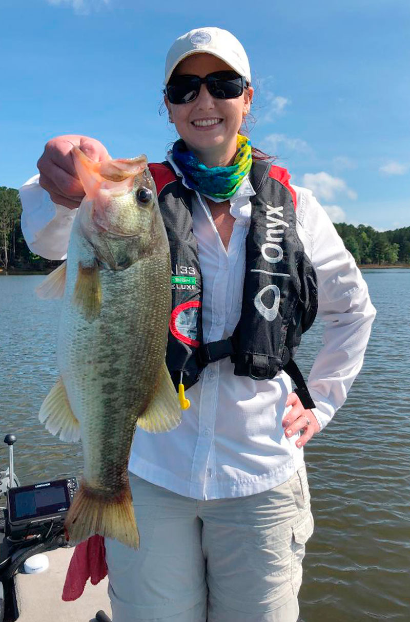
Joel Munday of Outdoor Expeditions Guide Service has been taking advantage of those roadways for bass for years.
“Bass can be caught from roadbeds almost year-round, but roadbeds are at their best in the summer; they’re also good in the fall,” Munday said. “I keep looking at my (depth finder) for bass and forage along a roadbed. Effective use of your electronics is necessary for successful roadbed fishing.”
Here’s a sampling of the roadbeds Munday targets in the summer at Jordan. Depths cited are approximate and with the lake at normal pool. Drawdowns may make larger segments of a roadbed fishable.
Johnson’s Bridge (North Pea Ridge Rd.). This roadbed enters the lake near the Vista Point boat landing and transverses the lake to Johnson’s Bridge and beyond. Munday said it consists of rock and rubble and bridge remnants with depths from 12 to 25 feet.
In the morning, the roadbed attracts schooling fish that can be caught with topwater baits like Pop-Rs. At times, bass can be seen chasing shad. During the day, Munday said he fishes the edges and high spots along the roadbed.
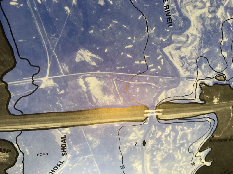
US 64 roadbed. The old U.S. 64 roadbed runs parallel and north of the US 64 causeway, entering the lake at Parker’s Creek and running until it passes a water intake where a deep channel cuts through it, then ends on the opposite bank near the Crosswinds boat ramp. An abandoned railway cuts through it as well.
During lake construction, excavation workers dug up some areas and dumped rock when constructing US 64, creating roadbed-like formations.
Munday said bass congregate on the high spots along the roadbed in water 8 to 14 feet deep. They consist of rubble and pavement.
During the mid-1980s, shortly after Jordan was opened to fishing, Lexington’s Jerry Lohr wore the bass out on those road-bed-like formations and high spots with crankbaits. Lohr often told his buddies before a tournament he was going to win at those spots, then he would make good on his prediction.
Lohr’s honey hole has become a fairly well-known hot spot for bass, so it’s not as loaded with fish as it once was, but it’s still a good place for catching quality bass.
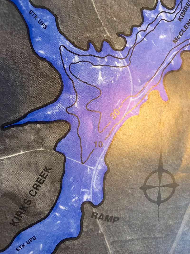
Kirk’s Creek (Rt. 1931): The roadbed enters the lake at the back of Kirk’s Creek near Poe’s Ridge Landing on the Haw River end of the lake. It runs along the right bank before it splits, with one section cutting across the creek while the other continues along the shore. The depth along the roadbed varies from 5 to 14 feet.
Munday said the roadbed is “as rough as a cob,” which explains its attraction for bass.
Ebenezer Landing roadbed: A roadbed runs roughly parallel behind the Beaver Creek Road bridge at the Ebenezer Landing. The roadbed is in 12 to 14 feet of water, and its rocky features lure quality bass. An early morning bite is possible near the bridge. Later in the day, anglers make their move to the roadbed.
Munday plucks bass from these roadbeds, basically using five baits: shaky head jigs, football jigs, Carolina rigs, Texas rigs and deep-diving crankbaits. Most of the fish come from 12 to 14 feet of water at high spots, drops and edges along the roadbeds.
He said the key to fishing roadbeds with crankbaits is to make long casts, so the deep-diving baits have enough time to reach their maximum depths, while covering as much of the productive part of the roadbed as possible. He usually retrieves them from shallow to deep. Crankbaits work best when the bass are active.
To make long casts, Munday uses a medium-action, 7-foot-3 13 Fishing baitcasting rod and reel spooled with 12-pound Seaguar fluorocarbon. For crankbaits, he favors Rapala’s DT Series in natural shad patterns with a touch of chartreuse.
“The baits have a steep bill that forces them down in a hurry,” he said. “Effective crankbaits bounce and bang along the rocky structure that comprises most roadbeds without hanging up too much.”
Munday’s Texas and Carolina rigs, used for slowly probing structure, feature soft-plastic baits in green pumpkin, junebug and red shad colors. He likes fishing light, shaky head jigs on shallower portions of rocky roadbeds because they’re less likely to hang. He fishes deeper waters for sluggish bass with football jigs in blue/black or peanut butter and jelly colors. He fishes a 7-foot-3, medium-heavy 13 Fishing rod and 15-pound fluorocarbon leader for shaky heads, Texas rigs and Carolina rigs.
Jordan Lake houses many other roadbeds within its 13, 940 acres. Fishermen utilizing topographical maps and/or their electronics rarely are at a loss for bass when they fish these underwater routes.
DESTINATION INFORMATION
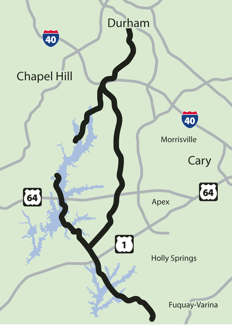
HOW TO GET THERE — Jordan Lake, south of Durham and southwest of Raleigh, has great access from US 64, which crosses the lake east-west approximately at mid-lake. Public ramps include Farrington Point and Crosswinds off Farrington Road, Ebenezer Church off Beaver Creek Road and Seaforth off US 64.
WHEN TO GO — Submerged roadbeds are very productive for summer and early fall bass fishing. Go with deeper roadbeds during the summer and move to shallower roadbeds in the fall.
BEST TECHNIQUES — Probe irregularities on offshore, submerged roadbeds with Carolina rigs, large shaky head jigs tipped with 8- to 10-inch worms, deep-diving crankbaits and 1/2- to 5/8-ounce jigs. Shallow- to medium-diving crankbaits and 1/4-ounce jigs take over in the fall.
FISHING INFO/GUIDES — Jowl Munday, Outdoor Expeditions Guide Service, 919-669-2959, www.outdoorexpeditionsusa.com; Jeffrey Thomas, Carolina Outdoors Guide Service, www.carolinaoutdoors.net. See also Guides & Charters in Classifieds.
ACCOMMODATIONS — Holiday Inn Express, Apex-Raleigh 800-307-2083; Budget Inn, Sanford, 919-775-2814; Hampton Inn & Suites, Chapel Hill, 919-403-8700; Comfort Inn, Apex, 919-387-4600. Campgrounds at Jordan Lake State Recreation Area, Apex, 919-362-0586.
MAPS — GMCO Maps, 888-420-6277, www.gmcomaps.com; Kingfisher Maps, 800-326-0257, www.kfmaps.com; FHS Maps, Jordan Lake, 800-ALL-MAPS, www.fishinghotspots.com.
The railroad that never was
When New Hope Dam was completed in 1982, creating Jordan Lake, numerous homes and communities were inundated by the lake’s waters, including the remnants of a railroad intended to connect Durham and the town of Duncan in southern Wake County.
The original rails were abandoned when a plan to construct a flood-control lake, originally named New Hope Lake but renamed B. Everett Jordan Lake in memory of the N.C. Senator, became inevitable as recorded in Durham to Duncan.
The historical record reads:
“In April 1969, the U.S. Army Corps of Engineers entered into a relocation agreement with the D&SC (Durham and South Carolina Railroad) and the Norfolk Railway, as a third party, to move the rail line from the New Hope Valley river basin to higher ground in preparation for the building of the New Hope Dam and Reservoir Jordan Lake.”
The abandoned railroad, depicted on topographical maps and at www.abandonedrails.com, offers fishermen a flooded road of another kind that serves as a magnet for fish.
Its covered remains cross the upper end of New Hope Little Creek near two islands and high-tension Duke Energy lines before re-entering the lake at Morgan Creek, crossing the creek, then re-entering the lake near Farrington Point, crossing Bush Creek, then hugging the shoreline until it reaches the N.C. Division of Forest Resources regional headquarters, then moving past Parkers Creek to the Shoal Buoy near the US 64 bridge at mid-lake and going to the opposite shore, crossing the mouth of Beaver Creek and continuing into Little Beaver Creek before exiting the lake after passing Covington’s Reef.
“While most of the old railroad bed is too deep for summer bass fishing because of thermoclines, those sections in 14 to 16 feet of water or less where it enters Morgan Creek, exits Little Beaver Creek and runs close to Farrington Point can be excellent for fishing,” said guide Joel Munday.