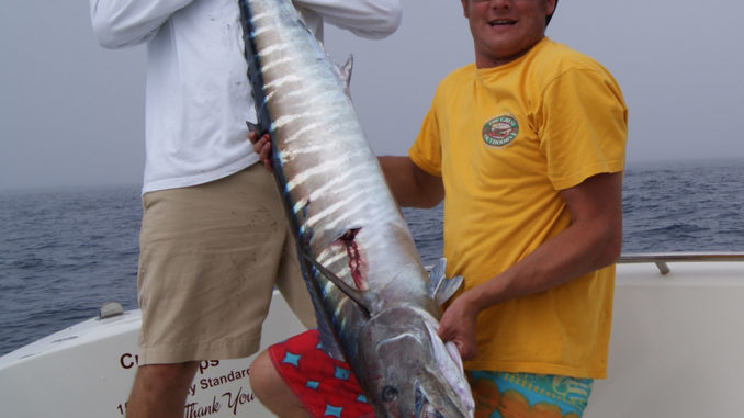
Bluewater fishermen can reach these powerful, speedy fish out of Little River in the spring, but they’d better take care; the meeting might not be friendly.
Bluewater fanatics should gear up this month as eddies of warm water move toward the shoreline, kicking off a flurry of action from a favorite reel screamer, the almighty wahoo.
As springtime conditions arrive, they create a niche for fishermen with a proven recipe to fill the fishbox with feisty wahoo in the clear, cobalt waters off the coast of Little River Inlet.
Their migratory movements remain part of the mysterious puzzle that is this interesting but tasty fish from the deep ocean blue. Compared to other pelagic, bottom-dwelling or inshore species, wahoo have not been studied extensively, and for whatever reason, larger concentrations begin to venture northward along the Gulf Stream from Florida late in the winter and begin to arrive of South Carolina’s coastline early in the spring. Fishermen pick up a few wahoo through the winter, and trips become more regular as temperatures rise in the spring and the northerly winds that buck the Gulf Stream current, causing rough waters, begin to dissipate.
Capt. David Cutler of Lowcountry Fishing Charters in Little River welcomes the arrival of spring and the more-suitable weather patterns that allow him to make more of his favorite bluewater excursions.
“In April and May, prevailing winds shift to (the south), laying down the ocean, and it allows us to get out there,” said Cutler (843-222-7433).
The southerly winds warm the water and cause shifts in the Gulf Stream current that control the movement of both predator and prey. They concentrate small tuna, jacks, flying fish and other forage fish in the warmer eddies that spin off the Stream. Wahoo will pinpoint these areas where food is concentrated.
Cutler looks for a temperature break with at least a 2-degree change when he looks to narrow his search for spring wahoo.
“At these temperature breaks, there will be a color change from the cooler, green water to the warmer, blue water,” he said. “Sometimes, there will be a rip identifying this temperature seam at the surface.”
Cutler uses his computer and satellite imagery to analyze sea-surface temperatures before he ever leaves the docks. He checks his data the night before a bluewater trip to get the most-accurate picture of where the temperature breaks and color changes might be.
“Night shots give you a true sea surface temperature versus biased data from the reflection of the sun during the daytime,” he said.
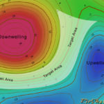
A temperature break might cover endless miles of ocean, but fishermen must narrow down the target area using smart resources to locate the wahoo. Capt. Jim Bowen, who also runs trips for Lowcountry Fishing Charters, utilizes Texas-based Rip Charts to gather pre-trip information, tracking changes and movements of currents to predict the ideal place to find wahoo. In addition, he gets data on changes in sea surface height, which reveals upwellings where the sea surface height is lower than normal.
“An upwelling produces a nutrient flow from the bottom towards the surface, providing a food source for baitfish and then our wahoo,” Bowen said.
True color satellite imagery and chlorophyll readings will show areas of clear water, areas, Cutler said, will hold the most wahoo.
“Look for the clear, cobalt-blue water,” he said. “If you find where green water abuts blue water, there is usually a temperature break there, and you are almost guaranteed to catch fish.”
Bowen and Cutler prefer to fish in areas with upwellings along the edges of the temperature breaks or eddies where the crystal-clear warm water pushes up against the cold water. Their fool-proof formula will strain reel drags to the max when these conditions come together.
“Find a point where all of these things come together, and the fish will be there and active,” Bowen said.
“We look for temperatures in the low- to mid-70s, and we prefer these eddies to be over a ledge or hump,” said Cutler, who looks for springtime wahoo to be congregated on the shallow side of a break or ledge in 175 to 375 feet of water. “Fish will be hanging in water depths just before the deep drops four to five miles out even to 500 feet of water.”
One of the places that fits all of Cutler’s prerequisites is the “Steeples” area, which is slightly more than 55 miles from Little River Inlet.
“There are pretty big columns (at the Steeples) with a good current break and wahoo wait around for baitfish to wash around these columns,” said Cutler, who will also hit well-known bluewater spots including the Blackjack Hole, 100/400, McMarlin Ledge, Georgetown Hole and Winyah Scarp when temperature breaks show up in those areas.
Cutler and Bowen usually troll back and forth across these rips or color changes. Baitfish and predators will usually be on opposite sides, with the baitfish hiding on the murky side, trying to avoid being inhaled by a passing wahoo.
“Typically, the bites will occur in the clear, blue water, but sometimes the bite will be on the darker or green water side,” he said.
Traditional tactics for catching wahoo are fairly typical, with ballyhoo fished with skirts in a variety of colors and sizes. Cutler will rig ,medium-sized ballyhoo — “Big ballyhoo doesn’t ride as well at eight knots as the middle-sized ones,” he said — on Illander lures in purple/black, red/black, pink/white, but he’ll run at least one naked: with no skirt. Depending on the day, certain colors tend to work better than others and some days the naked version will get the most attention.
Cutler likes to run six lines, with four attached to trolling weights from one to two pounds, a shotgun line, and a short line pulling a Yozuri plug just inside the prop wash.
Destination Information
HOW TO GET THERE/WHEN TO GO — The Gulf Stream and its inshore eddies are accessible from most inlets along the coastline of both Carolinas. Little River, on the northern end of the Grand Strand, is the South Carolina port with the shortest run to many of those bluewater hot spots. It’s accessible from US 17 from the south and SC 9 from inland. The best wahoo fishing is in the spring, from late March through May, and again in the fall, in September and October.
WHERE TO FISH — Use satellite imagery available on-line to locate warm-water eddies in 180 to 375 feet of water. Wahoo prefer water temperatures from 72 to 78; the best temperature breaks will show a difference of at least two degrees between the warmer and cooler sides. Wahoo will be most concentrated when the warm-water eddies are around breaks near the Steeples, Blackjack Hole, 100/400, Ledge, Georgetown Hole and Winyah Scarp — most of which are shown on offshore charts.
LURES/TECHNIQUES/TACKLE — For traditional trolling, pull medium ballyhoo rigged naked or on llanders in purple/black, red/black and pink/white. Run baits at and below the surface with 1- to 2-pound trolling weights, and troll at speeds between six and eight knots back and forth across temperature breaks, color changes or current rips. High-speed trolling at 15 to 17 knots can be very effective while in search mode or while approaching a predetermined location; it will produce mostly jumbo-sized fish. Ballyhood trolling lures in a variety of colors are preferred for high-speed trolling. Large hooks (12/0) are preferred for traditional and high-speed trolling; strong tackle is required to subdue fierce, powerful wahoo. Penn 30-Wide reels are recommended for normal trolling speeds, while 50-Wide reels and 50- to 80-pound bend rods are required to pull the heavy lures and rigs at high speeds. Spool reels with 40- to 60-pound mono or 150-pound braided line with long leaders of mono, fluorocarbon and heavy wire. Always replace the lure and leader after catching a fish; any tiny gash or nick in the line can be perilous when the next fish strikes.
FISHING INFO/GUIDES — Capt. David Cutler, Capt. Jim Bowen, Lowcountry Fishing Charters, Little River, 843-222-7433, http://www.lowcountryfishingcharters.com/. See also GUIDES & CHARTERS in Classifieds.
ACCOMMODATIONS — Myrtle Beach Area Convention and Visitors Bureau, http://www.visitmyrtlebeach.com/; South Carolina Association of Visitors Bureaus, http://www.discoversouthcarolina.com/.
MAPS/CHARTS — Rip Charts, 877-526-3442, http://www.ripcharts.com/; Navionics, 800-848-4896, http://www.navionics.com/; Maps Unique, 910-458-9923, www.mapsunique.com; Grease Charts by Nautical Publications, 800-326-3467.


Be the first to comment