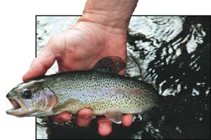
Mid-summer draws trout fishermen to headwater regions, where waters stay cool and trout remain active. In the high hills of Haywood County, a network of trout-filled branches rise to form the headwaters of the Pigeon River.
The Pigeon River carries a dirty reputation.
Infamous for its past polluted state, the river name still leaves a bad smell in the noses of many North Carolinians. In stark contrast to the often-stained river that flows lazily through Canton and toward the Tennessee border, the Pigeon’s headwaters consist of crystalline creeks that tumble swiftly down the steep slopes of the great Balsam Mountains. Tiny branches rise more than 5,000 feet above sea level, deep in the Shining Rock and Middle Prong wilderness areas. More than 25,000 acres of wilderness contain a half-dozen peaks that top 6,000 feet in elevation and countless remote waterfalls.
Trout abound in the forks that join forces to form the Pigeon River, with all streams within the two wilderness areas containing wild fish exclusively. The lower ends of most of the wilderness runs contain mostly brown trout, including some high-quality fish, along with a smattering of rainbows. Headwater branches are home to thriving brook trout populations.
“In the Pigeon Watershed, we sampled 40 populations of wild brook trout,” said Doug Besler, regional research coordinator for the N.C. Wildlife Resources Commission. “I’m sure we’ll find additional populations as we continue our brook trout genetics work.
“Statewide, we have sampled 445 populations of wild brook trout, so the Pigeon River watershed has a substantial amount of North Carolina’s wild brook trout.”
Besler said brook trout habitat is great in those streams that run through Forest Service lands, which includes most of the brook trout waters in the true headwaters region — those that join forces to form the Pigeon’s two major forks. Good riparian habitat and a dense canopy keep these streams clear and cold, and barrier falls prevent brown and rainbow trout from displacing native brook trout.
The fact the Pigeon’s headwaters remain cool all summer adds much appeal for dog-day trout outings. The chilly water feels good during steamy days, and trout remain active.
The Shining Rock and Middle Prong wilderness areas, with their high falls and beautiful, rugged landscapes, become quite popular among day-hikers and backpackers during the summer. However, fishing pressure remains only moderate, and anglers who venture more than a mile or two into the wilderness are apt to have long stretches of trout waters to themselves.
For anglers who favor stocked waters and easier access, the West Fork of the Pigeon River also offers 5 miles of hatchery-supported waters and an additional 2 miles of delayed-harvest waters, which fall under the same regulations as do the hatchery-supported waters during the summer and are stocked with nearly 1,000 trout during July.
The West Fork
The West Fork of the Pigeon River is by far the most diverse of the Pigeon’s tributary flows.
It contains wild brook trout in its headwaters, wild brown trout farther downstream, 5 miles of hatchery supported waters and 2 miles of delayed-harvest waters.
The West Fork rises near the summit of Mount Hardy and ends at its confluence with the East Fork, where the Pigeon River officially forms at the crossroads community of Bethel. Trout waters include all waters upstream of Lake Logan, a small mountain lake that’s bounded by private land.
Through the lower end of its trout waters, including delayed-harvest section and the lower reaches of its hatchery supported section, the West Fork is a large stream, and a moderate grade allows for easy wading.
The upper half of the hatchery-supported section pours through a gorge, crashing over many significant drops, racing between boulders and granite cliffs and collecting in massive plunge pools.
State Highway 215 parallels the West Fork, providing countless places for anglers to access the river throughout the hatchery-supported section and even well into wild trout waters.
The delayed-harvest section, which is located inside the Cold Mountain Game Land, offers an ideal destination for family outings. A ¼-mile access trail at the lower end of this section begins at a developed parking lot and offers outstanding access to a section of river that is easy to fish.
A broad gravel bed, much of which is dry given normal summer flows, offers bank access with nothing to obstruct backcasts. The river drops just enough to create deep runs and sufficient current to keep the trout from being too spooky.
Because the West Fork has not yet gained the immense popularity of many other delayed-harvest streams, the trout don’t all get caught out in a hurry when the harvest season opens.
The hatchery-supported section gets stocked monthly from May through July and receives a total of 3,525 trout, with rainbows, browns and brook trout contained in the mix. This section runs mostly through National Forest land.
Highway 215 forms a narrow corridor between the two wilderness areas, and the West Fork cuts from one wilderness to the other as the road crosses it.
The lower half of the West Fork’s wild trout waters contains mostly brown trout, although a modest number of rainbows are present. Moving upstream, brook trout enter the mix.
“Upstream of where the road goes through a major switchback and crosses the river for the last time, it’s almost all brook trout,” said Scott Loftis, the WRC’s watershed enhancement supervisor who served several years as the District 9 biologist and who lives in nearby Waynesville.
Middle Prong
The centerpiece of the Middle Prong Wilderness, the Middle Prong is a tributary of the West Fork that comes in at the lower end of the West Fork’s hatchery-supported section.
The Middle Prong rises on the northwestern slope of Mount Hardy, close to the Blue Ridge Parkway, and runs its entire course within the boundaries of its namesake wilderness area.
“The lower end of the Middle Prong offers very good brown trout fishing — if you hit it right,” Loftis said “If you hit it when it’s low and clear and the sun is shining, it will seem like there isn’t a trout in it. Like a lot of brown trout streams, it’s best late in the afternoon, especially after a good summer thunderstorm that brings the water up and adds a little color.”
The upper end of the Middle Prong contains all brook trout.
The stream becomes quite small by the time an angler gets to brook trout waters, however many sections are plenty steep to create abundant falls, which form large plunge pools.
All access to the Middle Prong is by foot, either along hiking trails, which parallel most of the stream, or up the stream bed. Trail access points are at Sunburst Campground along Highway 215, and at Haywood Gap, off the Blue Ridge Parkway.
“The Middle Prong lends itself to a very good weekend trip, working from once access point to the other and fishing for brook trout and brown trout,” Loftis said.
Working from Highway 215 to the Parkway allows anglers to fish upstream without doing as much backtracking. However, beginning at the parkway allows an angler to do most hiking with a pack downhill. That’s a significant distinction, with more than 2,100 vertical feet separating the two access points.
Little East Fork
The Little East Fork is a tributary West Fork, which adds its flow to the large stream downstream of Lake Logan.
Public trout waters are all in the upper two thirds of this stream’s flow and essentially begin at the Shining Rock Wilderness border.
A fairly small stream that is accessible only by foot, the Little East Fork contains mostly brown trout through the lower half of its public waters and brook trout in its headwaters.
“There are a couple pretty major waterfalls that serve as barriers between the brown trout waters and the brook trout waters,” Loftis said. “Reportedly, it’s a pretty good little brook trout fishery.”
The only access to the most of the Little East Fork is by hiking along the Little East Fork Trail. A couple miles of trail, quite a bit of climbing and a pretty small stream to crawl up together keep pressure pretty light in the upper Little East Fork.
The trail begins beside the Boy Scouts’ Camp Daniel Boone at the end of Little East Fork Road.
The East Fork
Similar to the West Fork, the East Fork of the Pigeon River is a fairly large trout stream at the lower end of its public section and offers several miles of public trout waters.
The East Fork, which is called Yellowstone Prong in its extreme headwaters, rises near the Blue Ridge Parkway on steep slopes of Black Balsam Knob at an elevation of more than 5,500 feet. The entire upper half of the streams run is on National Forest land, with much of the public portion within the Shining Rock Wilderness.
The East Fork’s headwaters, including Yellowstone Prong and Dark Prong, a major feeder, contain brook trout exclusively.
Yellowstone Prong pours over a few major waterfalls — Upper Falls, Second Falls and Yellowstone Falls. This section of creek parallels the Blue Ridge Parkway, and the trail that runs beside it is accessible off the Parkway in the Graveyard Fields area and at Bridges Camp Gap.
The lower end of the East Fork’s public waters, which is accessible off U.S. Highway 276 at the edge of the Shining Rock Wilderness, contains mostly brown trout, with some rainbows in the mix.
The East Fork Trail parallels the river for several miles before turning west to follow Greasy Cove Prong. Upstream of Greasy Cove prong, brook trout begin to show up in the East Fork.
Loftis said anglers should try to make at least one trip to the East Fork during September or October if they can.
“That’s when the big brown trout start moving around, looking for gravel beds for spawning,” he said. “I’ve seen multiple browns in the 20-inch class just by walking the trail that time of year. You may not be able to catch them, but at least you’ll know they’re there.”
Fishing the Forks
Anglers fishing the delayed-harvest or hatchery-supported waters t the West Fork can use the same in-line spinners, minnow-shaped plugs and natural offerings that work well on other large stocked stream. Fly-fishermen likewise can catch trout using a number of different fly types in these waters.
Wild trout waters, where only single-hook artificial lures may be used, present a different story.
The wild trout waters in the forks of the Pigeon stay very clear, especially during late summer, when they tend to run low. Small flies, jigs or spinners are usually required, as are very light lines and leaders. For the same reason, a stealthy approach and natural presentations are absolutely critical.
During the summer, wild trout will be looking up and will feed opportunistically on passing insects, both on the surface and in the first couple feet beneath the surface. Arguably the most efficient way to target these fish is with a fairly small dry fly rigged with a very small nymph 18 inches or so beneath it on a dropper line.
This rig offers the fish two different looks at different levels. Plus, the dry fly serves as a nice strike indicator when trout take the nymph. In small headwaters areas, the dropper is best left off for the sake of easier casting in very tight sections of stream.
Wild brook trout will strike once at just about any small fly or spinner that’s well presented; however, they won’t hold on long, and they’ll rarely hit anything twice. They also won’t touch a fly that has any unnatural drag or any lure that passes in an unnatural direction.
Brown trout are far fussier, and there are no guarantees.
Anglers should stay well back from promising-looking runs and experiment with flies.
Brown trout fishing is best by far early and late in the day and during cloudy days.


Be the first to comment